Shapefile over Map (Demo)
Load your own shapefiles, visualize them over a map and edit its dbf values.
DabeBro · com.dabebro.somdemo


UpdatedMar 28, 2018
PublishedMar 28, 2018
Packagecom.dabebro.somdemo
MD56c08d3da419051225b88b9135efe9ef7
SHA1 (signer)E7:C1:E2:15:D6:3A:A2:37:A0:BD:10:CF:CA:F5:28:7F:21:4C:7C:45
Signed byCN=Daniel Beneito, OU=Graficos, O=DabeBro, L=Valencia, ST=Valencia, C=ES
Malware scanTRUSTED
Contact[email protected]
What's new
Support for all UTM Projections.
The .prj file is readed and the coordinate system is automatically assigned.
Now you can save your sessions (a configured shapefile list).
New drawing system. Now move the map is faster
New layers administration system
New tool to load the last session
New auto zoom tool to the active layer
Added new tool to measure distances, areas and perimeters (Full version only)
Added new map servers: Road, Aerial and Aerial with labels(Full version only)
Description
Load your own shapefiles with this Geographic Information System (GIS) directly from the sdcard of your mobile device and visualize them over a map. You can also edit the values of its dbf table and use it in offline mode, loading maps from your memory card.
With this GIS application, you can select and load a shp file or load an entire folder automatically.
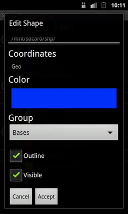
You can select one of these shp files and mark it as the active layer and if you do a long press over one of them you can change its coordinate system, its color or make it invisible.
The map will display a series of icons, belonging to each of the records in the active layer, which when pressed will allow you to view and edit information from its corresponding attribute table.
The application also allows you to view your current position via GPS and center the map on it.
You can choose between several online map servers.
This is a demo version, some functionalities are only available in the full version.
Load your own shapefiles with this Geographic Information System (GIS) directly from the sdcard of your mobile device and visualize them over a map. You can also edit the values of its dbf table and use it in offline mode, loading maps from your memory card.
With this GIS application, you can select and load a shp file or load an entire folder automatically.
You can select one of these shp files and mark it as the active layer and if you do a long press over one of them you can change its coordinate system, its color or make it invisible.
The map will display a series of icons, belonging to each of the records in the active layer, which when pressed will allow you to view and edit information from its corresponding attribute table.
The application also allows you to view your current position via GPS and center the map on it.
You can choose between several online map servers.
This is a demo version, some functionalities are only available in the full version.
Load your own shapefiles with this Geographic Information System (GIS) directly from the sdcard of your mobile device and visualize them over a map. You can also edit the values of its dbf table and use it in offline mode, loading maps from your memory card.
With this GIS application, you can select and load a shp file or load an entire folder automatically.
You can select one of these shp files and mark it as the active layer and if you do a long press over one of them you can change its coordinate system, its color or make it invisible.
The map will display a series of icons, belonging to each of the records in the active layer, which when pressed will allow you to view and edit information from its corresponding attribute table.
The application also allows you to view your current position via GPS and center the map on it.
You can choose between several online map servers.
This is a demo version, some functionalities are only available in the full version.
Required features
- Touchscreen android.hardware.touchscreen
Permissions (5)
Shapefile over Map (Demo) requests the following Android permissions:
- Access Coarse Location android.permission.ACCESS_COARSE_LOCATION
- Access Fine Location android.permission.ACCESS_FINE_LOCATION
- Access Network State android.permission.ACCESS_NETWORK_STATE
- Internet android.permission.INTERNET
- Write External Storage android.permission.WRITE_EXTERNAL_STORAGE