


UpdatedJul 16, 2021
PublishedJul 16, 2021
Packagecom.stentec.wingps_marine_lite
MD5cbfe41238c8e66bc7195d89a6b2593d1
SHA1 (signer)B5:7C:6C:C6:52:A9:50:3D:68:E5:5A:C5:D8:20:EC:DC:55:64:5B:3F
Signed byO=Stentec
Malware scanTRUSTED
Websitehttp://www.stentec.com
Contact[email protected]
Privacy policyView
What's new
- Solution for problems with downloading and storage of maps and other files.
- Solution for problems displaying of waterway-network.
- Improvements in efficiency of downloads of Waterway-Network.
- WinGPS Marine now needs less information from your device.
- Solution for problems displaying of waterway-network.
- Improvements in efficiency of downloads of Waterway-Network.
- WinGPS Marine now needs less information from your device.
Description
WinGPS™ Marine: Navigation on board using your tablet or smartphone.
With this app, route and waypoint navigation on nautical charts is easier than ever. The grib weather prediction and AIS schip tracking are both essential for safe navigation.
Developed by Stentec for sailing or power boats and kayaks. Ideal for ship owners, crew as well as for chartering.
NEW
• Smart labeling for waypoint and structure names. For an optimal view even at rotating charts.
• Easy creation of routes on the most comprehensive waterway network for European Inland charts. US will follow later. Insert additional route points to avoid blockages shown in red.
HIGHLIGHTS
• Navigate on high quality charts (Stentec, Delius Klasing, NV-Verlag, Imray, user made, NOAA online only. Off-line use of stored NOAA charts is planned for a future update.
• North-up (Lite), Course-up (Marine) and Head-up (Plus) GPS tracking.
• Very user friendly way to create and edit waypoint and routes.
• Easy management of tracks, charts, routes and waypoints.
• Worldwide NOAA GFS 1/4 degree grib files of wind, air pressure, and precipitation
• Connect AIS and GPS wirelessly using a WIFI or Bluetooth connection.
• Avoid collisions with the velocity vectors of AIS vessels around you.
• The man-overboard button marks and points to the position of a lost crew member.
• NOAA waves world wide
IN-APP PURCHASE
After purchasing WinGPS™ Marine you unlock the full features of the app. Check out the various possibilities on www.wingpsmarine.com.
When first installing the app you will get the Lite version of WinGPS™ Marine.
This version is limited functionality. With your GPS (internal or Bluetooth) you get the SOG and COG and you will see the current position on your screen.
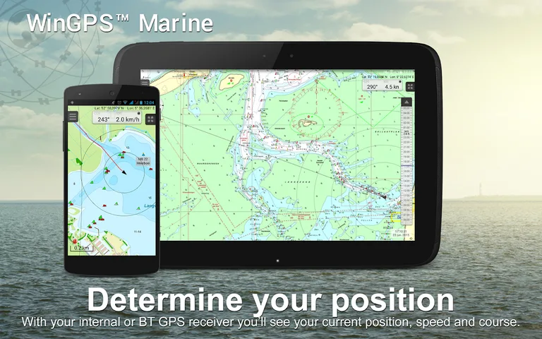
WinGPS™ Marine is the navigation app that allows true marine navigation on your Android device. In this app you can use the digital nautical charts for route planning with GPS via WIFI or Bluetooth. You can also get data from AIS, GRIB meteo and record the tracks you have sailed. Use the "timebar" to explore the predicted weather shown on the chart.
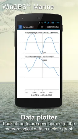
The WinGPS™ Marine Plus upgrade provides you all the best of the Marine Apps. This advanced navigation app helps you plan routes under every condition. Connect your tablet or smartphone to your PC, WIFI AIS transponder od board system. Tidal & current Grib predictions can be displayed in the data plotter, and on your chart screen.
CHART COVERAGE & INSTALLING CHARTS
When starting WinGPS™ Marine you will automatically use the ESRI topographic base chart. You can also download the free world chart via the chart manager.
The most easy way to buy chart sets for your WinGPS Marine app is in our online shop at www.stentec.com or alternatively use the Google Play ™ store. After purchasing a chart set you get a license code for 2 systems (with a third as backup). This enables you to use the charts on your Android device as well as on your laptop/PC.
If you login in WinGPS™ Marine, you can download your DKW chart sets in the chart manager. Updates are downloaded starting up the app.
Examples of DKW Charts are: Stentec’s DKW charts, UKHO, BSH, Imray, Delius Klasing and the DKW 1800 series with weekly BaZ update service. Also Free NOAA charts are supported. The database of Vaarkaart Nederland is updated monthly. This well sold chart covers all inland waterways including IJsselmeer.
Use our free DKW Manager to install BSB charts on PC and copy these to the DKW2 directory of your tablet using an USB cable. This is also possible for scanned charts created with our DKW Builder.
USER FEEDBACK
We are very interested in your experiences with this app and your suggestions so that we can use it to improve this app. If you got any suggestions, please send an e-mail to [email protected].
With this app, route and waypoint navigation on nautical charts is easier than ever. The grib weather prediction and AIS schip tracking are both essential for safe navigation.
Developed by Stentec for sailing or power boats and kayaks. Ideal for ship owners, crew as well as for chartering.
NEW
• Smart labeling for waypoint and structure names. For an optimal view even at rotating charts.
• Easy creation of routes on the most comprehensive waterway network for European Inland charts. US will follow later. Insert additional route points to avoid blockages shown in red.
HIGHLIGHTS
• Navigate on high quality charts (Stentec, Delius Klasing, NV-Verlag, Imray, user made, NOAA online only. Off-line use of stored NOAA charts is planned for a future update.
• North-up (Lite), Course-up (Marine) and Head-up (Plus) GPS tracking.
• Very user friendly way to create and edit waypoint and routes.
• Easy management of tracks, charts, routes and waypoints.
• Worldwide NOAA GFS 1/4 degree grib files of wind, air pressure, and precipitation
• Connect AIS and GPS wirelessly using a WIFI or Bluetooth connection.
• Avoid collisions with the velocity vectors of AIS vessels around you.
• The man-overboard button marks and points to the position of a lost crew member.
• NOAA waves world wide
IN-APP PURCHASE
After purchasing WinGPS™ Marine you unlock the full features of the app. Check out the various possibilities on www.wingpsmarine.com.
When first installing the app you will get the Lite version of WinGPS™ Marine.
This version is limited functionality. With your GPS (internal or Bluetooth) you get the SOG and COG and you will see the current position on your screen.
WinGPS™ Marine is the navigation app that allows true marine navigation on your Android device. In this app you can use the digital nautical charts for route planning with GPS via WIFI or Bluetooth. You can also get data from AIS, GRIB meteo and record the tracks you have sailed. Use the "timebar" to explore the predicted weather shown on the chart.
The WinGPS™ Marine Plus upgrade provides you all the best of the Marine Apps. This advanced navigation app helps you plan routes under every condition. Connect your tablet or smartphone to your PC, WIFI AIS transponder od board system. Tidal & current Grib predictions can be displayed in the data plotter, and on your chart screen.
CHART COVERAGE & INSTALLING CHARTS
When starting WinGPS™ Marine you will automatically use the ESRI topographic base chart. You can also download the free world chart via the chart manager.
The most easy way to buy chart sets for your WinGPS Marine app is in our online shop at www.stentec.com or alternatively use the Google Play ™ store. After purchasing a chart set you get a license code for 2 systems (with a third as backup). This enables you to use the charts on your Android device as well as on your laptop/PC.
If you login in WinGPS™ Marine, you can download your DKW chart sets in the chart manager. Updates are downloaded starting up the app.
Examples of DKW Charts are: Stentec’s DKW charts, UKHO, BSH, Imray, Delius Klasing and the DKW 1800 series with weekly BaZ update service. Also Free NOAA charts are supported. The database of Vaarkaart Nederland is updated monthly. This well sold chart covers all inland waterways including IJsselmeer.
Use our free DKW Manager to install BSB charts on PC and copy these to the DKW2 directory of your tablet using an USB cable. This is also possible for scanned charts created with our DKW Builder.
USER FEEDBACK
We are very interested in your experiences with this app and your suggestions so that we can use it to improve this app. If you got any suggestions, please send an e-mail to [email protected].
Required features
- Faketouch android.hardware.faketouch
- Location android.hardware.location
- Wifi android.hardware.wifi
Permissions (17)
WinGPS™ Marine requests the following Android permissions:
- Access Fine Location android.permission.ACCESS_FINE_LOCATION
- Access Network State android.permission.ACCESS_NETWORK_STATE
- Access Wifi State android.permission.ACCESS_WIFI_STATE
- Bluetooth android.permission.BLUETOOTH
- Bluetooth Admin android.permission.BLUETOOTH_ADMIN
- Change Wifi Multicast State android.permission.CHANGE_WIFI_MULTICAST_STATE
- Change Wifi State android.permission.CHANGE_WIFI_STATE
- Foreground Service android.permission.FOREGROUND_SERVICE
- Internet android.permission.INTERNET
- Manage External Storage android.permission.MANAGE_EXTERNAL_STORAGE
- Read External Storage android.permission.READ_EXTERNAL_STORAGE
- Vibrate android.permission.VIBRATE
- Wake Lock android.permission.WAKE_LOCK
- Write External Storage android.permission.WRITE_EXTERNAL_STORAGE
- Com Android Vending Billing com.android.vending.BILLING
- Com Android Vending Check License com.android.vending.CHECK_LICENSE
- Permission Provide Background com.google.android.permission.PROVIDE_BACKGROUND