UTM Geo Map APK

Version 1.8.0 - info.yogantara.utmgeomap
info,yogantara,utmgeomap,maps,navigation

Lat Long, UTM & MGRS Converter, Address Geocoding, GIS, Map & GPS Coordinates

APP Information

Download Version 1.8.0 (80)
Apk Size6.45 MB
App DeveloperY2 Tech
Malware CheckTRUSTED
Install on Android4.1.x and up
App Packageinfo.yogantara.utmgeomap.apk
MD543695df349d07199c6c1ed57f649840d
Rate5
Website http://www.yogantara.info

Download UTM Geo Map 1.8.0 APK

App Description

UTM Geo Map is info,yogantara,utmgeomap,maps,navigation, content rating is Everyone (PEGI-3). This app is rated 5 by 1 users who are using this app. To know more about the company/developer, visit Y2 Tech website who developed it. info.yogantara.utmgeomap.apk apps can be downloaded and installed on Android 4.1.x and higher Android devices. The Latest Version of 1.8.0 Available for download. Download the app using your favorite browser and click Install to install the application. Please note that we provide both basic and pure APK files and faster download speeds than APK Mirror. This app APK has been downloaded 6252+ times on store. You can also download info.yogantara.utmgeomap APK and run it with the popular Android Emulators.

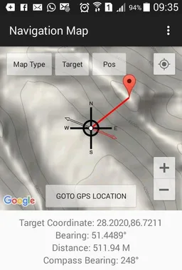
- Get Latitude Longitude, UTM WGS 84 & MGRS coordinates from GPS / Map in real time. Create marker / marking point and save coordinates data into database, copy all marker data to clipboard or export to KML, GPX or CSV.

- Measure multiple marker complete with unique ID, coordinates (latitude longitude, UTM & MGRS), address, elevation msl (premium), editable notes / labeling & date taken. This data can be stored in local database with unlimited numbers, use as source data for analysis (buffering, overlay & TIN data) or export to KML, GPX or CSV and save to your google drive for further use.

- Offline GPS with Latitude Longitude, UTM & MGRS Coordinates, Altitude, Elevation MSL, Accuracy, Speed, Bearing & Satellite Information.

- Convert Latitude & Longitude (dd & dms) to UTM (WGS 84) & MGRS vice versa. Share, save to database, save to clipboard or show results on the map.

- Batch converter from Latitude Longitude and MGRS Coordinates.

- Area & distance measurement (support units: m, km, ft, mile, hectare, acre), save line / polygon & area / distance results in database. Show multiple polygon and line in the map, export line & polygon to KML, GPX or CSV. Perform smoothing, buffering & overlay for simple GIS analysis. Auto generate polygon from marker data using Convex Hull, split polygon by line / polyline, delete marker inside or outside polygon, snap nearest object. Option to change line / polygon background color. Show label for each line / polygon: ID, custom note / label or area / distance value.

- Sophisticated & customizable Line & polygon smoothing using cubic bezier interpolation in Area / Distance measurement, design for collecting linear data to use in buffering & overlay analysis.

- Buffering: Create buffer map polygon with specific distance from existing marker (fix or variable buffer) or line & polygon from A/D measurement data (also support for negative buffer). Save buffer in database or export to KML, GPX or CSV.

- Buffer overlay tools for simple GIS analysis (union, intersection & difference).

- TIN view (triangulated irregular network, using delaunay triangulation), Voronoi Diagram, Convex Hull, Fix Buffer & Variable Buffer view in Marker Map module.

- Save geometry (Delaunay Triangulation, Voronoi Diagram, Convex Hull, Fix Buffer, Variable Buffer) to KML file and stored in Google Drive.

- Search for location on the map based on Latitude Longitude / UTM / MGRS / GPS coordinates / Marker ID / Address.

- Calculate bearing / azimuth & distance between 2 Latitude Longitude / UTM / MGRS / GPS coordinates.

- Compass with geodetic & magnetic azimuth / bearing & magnetic declination.

- Geocoding & reverse geocoding (convert address to coordinates & convert coordinate to address). This premium process needs internet connection.

- Elevation profile / elevation chart, support units metric & ft/mile from manual measurement, using available markers or auto generate route. Get free elevation for each measure markers.

- Load KML & GeoJSON file as a reference.

Elevation (needs data / internet connection) now available to buy on premium section. Every marker measured and coordinate converter results (except batch converter) will be completed with elevation data.

Free option to get MSL elevation with lower accuracy are available using Offline GPS, this elevation is base on EGM 96 15' Geoid model. Other free option to get elevation data can be found in Elevation Profile module & Marker Data List module. 

Download App Quick Start Guide (pdf): http://www.yogantara.info/utmgeomapquickstart.pdf  

Visit our website: http://www.yogantara.com

Tutorial on YouTube Channel: https://www.youtube.com/channel/UCspxQ5nQiqRD88g_-6GcCqw

Any suggestions are welcome, please email to [email protected] or write a review. Thank you. 

App ChangeLog

  • Ver 1.7.9 comes with lots of new features:
  • Marker Map Module:
  • - Delete marker inside polygon.
  • - Delete marker outside polygon.
  • - Create centroid marker.
  • - Snap marker to line / polygon object.
  • - etc.
  • Area/Dist Measure Module:
  • - Snap nearest.
  • - Split polygon by line / polyline.
  • - Marker magnet.
  • Compass Map Module:
  • - Set line / polygon object as target.

App Screens

UTM Geo Map App Screen 1UTM Geo Map App Screen 2

info-yogantara-utmgeomap-80-42627989-43695df349d07199c6c1ed57f649840d.apk

Apk scan results


Apk Scaned By TotalVirus Antivirus,info.yogantara.utmgeomap.apk Was Risky.Detected 1 From 55 Scan.
Scan Stats:harmless:0|type-unsupported:10|suspicious:0|confirmed-timeout:0|timeout:0|failure:1|malicious:0|undetected:64|
Name:info-yogantara-utmgeomap-80-42627989-43695df349d07199c6c1ed57f649840d.apk
SHA-1:a1921befc740a6d4e329404ecb4dd9658e4f4b1c
SHA-256:80e2cdbd1d139b3ff35f028c250b774fdf525130c75dc8580eb7467331434b91
SSDEEP:98304:qnUU4HwOGDyLMJPOw2cNxhSk70hK4V5VUafCuMyLg/h5/WQGL9yzMi1MI/6ImHbx:q0mDy8Yk70hK05V56yDL9yrp63nVqMPJ
File type:Android
Magic:Zip archive data
File size:6760320
Uncompressed Size:13075300
Contained Files	:595
Contained Files By Type:xml:355,dex:2,MF:1,DAC:1,pro:1,kml:20,RSA:1,txt:1,SF:1,png:142,

Older Versions

More Android Apps to Consider

Google Play Reviews

  1. Ali Mohsennejad-avatar

    Ali Mohsennejad

    This app is the best 😍😍 Find gps point Find utm point Find every other cods ... And convert cods And keep area points And show the area and ... And many other abilities... And ofcourse with thair updates, all good things left unchanged, 😌

  2. Porya Rostami-avatar

    Porya Rostami

    I use mostly the offline GPS, it's a great. All in all, this is a useful and practical app I like it, thanks to Its developers.

  3. Ravi Kanth Yella-avatar

    Ravi Kanth Yella

    Easy to measure and check the correctness of my Agricultural land, both areas and lengths. With 1% errors. For an android app that is more than satisfactory.

  4. Megharam Parmar-avatar

    Megharam Parmar

    Best uses in remote areas, I used it to identified and locate point/ positions particularly in Hilly & dance forest Mining areas. Thanks.

  5. Bien Agiter-avatar

    Bien Agiter

    Likes to recycle the change log. Rinse and repeat! Same old same old for change log. Rinse and repeat. Blah blah blah.

  6. Aletor Blakes Dennis-avatar

    Aletor Blakes Dennis

    Beautiful app. Recent problems, I can't export my saved area measures to internal storage. Only options available are to share the file which bringsbout only text information about the measurements but not the kml or kmz file. Pls urgent help needed.

  7. Boccor Joseph-avatar

    Boccor Joseph

    Very good application but its accuracy too large

  8. Abdulmajid Neja-avatar

    Abdulmajid Neja

    Really the best app for using to calculate area that we want measure and it have simple tools such like polygon polyline and points so im really staying with you on comfortable spat tanks so much

  9. Shahzaib Rasool-avatar

    Shahzaib Rasool

    Incredible application. Thank To Developers for such a nice App.

  10. Donald Jiak-avatar

    Donald Jiak

    Very good, well prepared map legends and other neccessary features for tracking and traveling in a map.