
SityTrail hiking trail GPS
Hiking GPS for all your outdoor activities in the world !
Geolives S.A. · com.geolives


UpdatedMar 31, 2026
PublishedMar 19, 2021
Packagecom.geolives
MD59a3deb654be56c1eec34c4ff70749999
SHA1 (signer)18:B8:9B:5D:6C:13:B1:16:FB:E7:8B:83:33:90:4A:21:56:5F:AA:9F
Signed byCN=Yves Peeters, OU=Geolives S.A., O=Geolives S.A., L=Luxembourg, ST=Luxembourg, C=LU
Architecturesx86, x86-64, armeabi-v7a, arm64-v8a
Malware scanTRUSTED
Websitehttps://www.sitytrail.com
Contact[email protected]
Privacy policyView
What's new
Several bug fixes and improvements.
Description
Go and discover all the paths around the world
• Record your trails while taking HD and geo-tagged pictures of your adventures.
• Travelled distance, Km-effort, average speed, calories burned, etc.
• Accurate altimeter, height differences computing and elevation profile displaying your current location.
• Alarm when you go off the path of the trail being followed. No more need to backtrack!
• Automatic triggering of points of interest with text-to-speech.
• Create a free account and all your data will be available everywhere on every device.
• Easy creation of trails and points of interest from our website.
• With our online editor, create your own trails using a Web browser on your PC/Mac and then access them directly from your smartphone to experience them on the ground.
• Sort and classify your trails and points of interest in your own lists.
Go further and become a PREMIUM user!
• Download world topographic maps for offline use.
• Discover GR hiking paths, European hiking routes, Santiago de Compostela routes for pilgrims, etc.
• Add topographic maps of your choice, from IGN France, IGN / NGI Belgium, IGN Spain, swisstopo, Austria, USA (USGS topographic mapping), Canada (Toporama).
• You can also discover all cycling networks: Greenway network in France, Ravel in Belgium, European cycling routes, knot points networks in Flanders and the Netherlands.
• And in winter, discover all the ski slopes with their names.
• Access the public catalogue of trails from SityTrail members and communities.
• Advanced tracking and guiding features with calculation of the remaining distance and time and vocal instructions at intersections.
• Go further and transform your favourite trails into real multimedia guides with text, photos, video links, and share them with the SityTrail community.
• Create your own hiker communities and manage your members and newsfeeds.
• Create trails with our advanced features for trail editing via our website.
• Print trails in PDF format with QR codes. (A4, A3).
• Access geotagged Wikipedia articles from our SityTrip module.
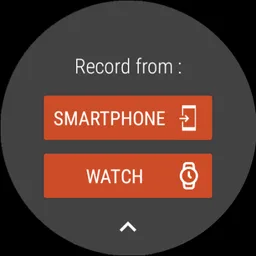
Record a trail on your Wear OS watch
You can record a trail on your Wear OS watch in standalone mode (not connected to an Android smartphone) or in paired mode (connected to an Android smartphone).
The application also allows logging in to your existing SityTrail account (from the screen which is the most on the left) when the watch is used in standalone mode.
Important Information
• Some features need an internet connection.
• The prolonged use of GPS can reduce battery levels.
• Record your trails while taking HD and geo-tagged pictures of your adventures.
• Travelled distance, Km-effort, average speed, calories burned, etc.
• Accurate altimeter, height differences computing and elevation profile displaying your current location.
• Alarm when you go off the path of the trail being followed. No more need to backtrack!
• Automatic triggering of points of interest with text-to-speech.
• Create a free account and all your data will be available everywhere on every device.
• Easy creation of trails and points of interest from our website.
• With our online editor, create your own trails using a Web browser on your PC/Mac and then access them directly from your smartphone to experience them on the ground.
• Sort and classify your trails and points of interest in your own lists.
Go further and become a PREMIUM user!
• Download world topographic maps for offline use.
• Discover GR hiking paths, European hiking routes, Santiago de Compostela routes for pilgrims, etc.
• Add topographic maps of your choice, from IGN France, IGN / NGI Belgium, IGN Spain, swisstopo, Austria, USA (USGS topographic mapping), Canada (Toporama).
• You can also discover all cycling networks: Greenway network in France, Ravel in Belgium, European cycling routes, knot points networks in Flanders and the Netherlands.
• And in winter, discover all the ski slopes with their names.
• Access the public catalogue of trails from SityTrail members and communities.
• Advanced tracking and guiding features with calculation of the remaining distance and time and vocal instructions at intersections.
• Go further and transform your favourite trails into real multimedia guides with text, photos, video links, and share them with the SityTrail community.
• Create your own hiker communities and manage your members and newsfeeds.
• Create trails with our advanced features for trail editing via our website.
• Print trails in PDF format with QR codes. (A4, A3).
• Access geotagged Wikipedia articles from our SityTrip module.
Record a trail on your Wear OS watch
You can record a trail on your Wear OS watch in standalone mode (not connected to an Android smartphone) or in paired mode (connected to an Android smartphone).
The application also allows logging in to your existing SityTrail account (from the screen which is the most on the left) when the watch is used in standalone mode.
Important Information
• Some features need an internet connection.
• The prolonged use of GPS can reduce battery levels.
Required features
- Faketouch android.hardware.faketouch
- Location android.hardware.location
- Screen Portrait android.hardware.screen.portrait
Permissions (27)
SityTrail hiking trail GPS requests the following Android permissions:
- Access Adservices Ad Id android.permission.ACCESS_ADSERVICES_AD_ID
- Access Adservices Attribution android.permission.ACCESS_ADSERVICES_ATTRIBUTION
- Access Adservices Custom Audience android.permission.ACCESS_ADSERVICES_CUSTOM_AUDIENCE
- Access Adservices Topics android.permission.ACCESS_ADSERVICES_TOPICS
- Access Coarse Location android.permission.ACCESS_COARSE_LOCATION
- Access Fine Location android.permission.ACCESS_FINE_LOCATION
- Access Network State android.permission.ACCESS_NETWORK_STATE
- Authenticate Accounts android.permission.AUTHENTICATE_ACCOUNTS
- Camera android.permission.CAMERA
- Foreground Service android.permission.FOREGROUND_SERVICE
- Foreground Service Data Sync android.permission.FOREGROUND_SERVICE_DATA_SYNC
- Foreground Service Location android.permission.FOREGROUND_SERVICE_LOCATION
- Get Accounts android.permission.GET_ACCOUNTS
- Internet android.permission.INTERNET
- Manage Accounts android.permission.MANAGE_ACCOUNTS
- Post Notifications android.permission.POST_NOTIFICATIONS
- Request Ignore Battery Optimizations android.permission.REQUEST_IGNORE_BATTERY_OPTIMIZATIONS
- Use Biometric android.permission.USE_BIOMETRIC
- Use Credentials android.permission.USE_CREDENTIALS
- Use Fingerprint android.permission.USE_FINGERPRINT
- Vibrate android.permission.VIBRATE
- Wake Lock android.permission.WAKE_LOCK
- Com Android Vending Billing com.android.vending.BILLING
- Com Geolives Dynamic Receiver Not Exported Permission com.geolives.DYNAMIC_RECEIVER_NOT_EXPORTED_PERMISSION
- C2dm Permission Receive com.google.android.c2dm.permission.RECEIVE
- Finsky Permission Bind Get Install Referrer Service com.google.android.finsky.permission.BIND_GET_INSTALL_REFERRER_SERVICE
- Gms Permission Ad Id com.google.android.gms.permission.AD_ID