


UpdatedJun 1, 2017
PublishedJun 1, 2017
Packagecom.ftpcafe.satfinder
MD500f369ce36f98ddb61dd8d8f4a695f35
SHA1 (signer)26:99:95:EA:43:06:FE:6A:4B:F7:FD:33:3E:BD:40:1A:6A:43:72:5F
Signed byCN=Dragan Andric, OU=ftpcafe.com, O=ftpcafe.com, L=London, ST=England, C=GB
Malware scanTRUSTED
Websitehttp://www.droidwareuk.com
Contact[email protected]
Privacy policyView
What's new
v3.1.2 - small bug fixes
v3.1.1 - Added vibration option in Target View
If you'd like to help translating SatFinder to French, Spanish or Russian, please contact us @ [email protected]
v3.1.1 - Added vibration option in Target View
If you'd like to help translating SatFinder to French, Spanish or Russian, please contact us @ [email protected]
Description
SatFinder, an Android satellite finder.
SatFinder is a tool for finding TV satellites and aligning satellite dishes. Use you AR camera view to see and target satellites in the sky.
*New feature: Ability to manually enter Location latitude and longitude details in case Location cannot be automatically determined in case of "no connectivity"
SatFinder uses your phone sensors to detect your physical location and calculates azimuth and elevation needed for your satellite antenna to face.
Augmented Reality View:
Use your camera for Augmented Reality View which paints the satellite icons in places where they're positioned in the sky. It gives a realistic view to the sky and it helps to make sure there is a line of sight (LOS), i.e. no obstacles, such as tree branches or house tops, between the satellite dish and the satellite itself.
- Touch screen to take a screenshot of Augmented Reality view
- Pinch to zoom satellites in and out. Double tap to reset.
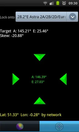
Target Satellite View:
Use Target Satellite View to find or to "lock onto" a particular satellite. Direction arrows simply guide you to the desired satellite position.
SatFinder is a tool for finding TV satellites and aligning satellite dishes. Use you AR camera view to see and target satellites in the sky.
*New feature: Ability to manually enter Location latitude and longitude details in case Location cannot be automatically determined in case of "no connectivity"
SatFinder uses your phone sensors to detect your physical location and calculates azimuth and elevation needed for your satellite antenna to face.
Augmented Reality View:
Use your camera for Augmented Reality View which paints the satellite icons in places where they're positioned in the sky. It gives a realistic view to the sky and it helps to make sure there is a line of sight (LOS), i.e. no obstacles, such as tree branches or house tops, between the satellite dish and the satellite itself.
- Touch screen to take a screenshot of Augmented Reality view
- Pinch to zoom satellites in and out. Double tap to reset.
Target Satellite View:
Use Target Satellite View to find or to "lock onto" a particular satellite. Direction arrows simply guide you to the desired satellite position.
Required features
- Camera android.hardware.camera
- Location android.hardware.location
- Location Gps android.hardware.location.gps
- Sensor Accelerometer android.hardware.sensor.accelerometer
- Sensor Compass android.hardware.sensor.compass
- Touchscreen android.hardware.touchscreen
Permissions (7)
SatFinder - Find TV Satellites requests the following Android permissions:
- Access Fine Location android.permission.ACCESS_FINE_LOCATION
- Access Network State android.permission.ACCESS_NETWORK_STATE
- Camera android.permission.CAMERA
- Vibrate android.permission.VIBRATE
- Wake Lock android.permission.WAKE_LOCK
- Write External Storage android.permission.WRITE_EXTERNAL_STORAGE
- Com Android Vending Check License com.android.vending.CHECK_LICENSE