


UpdatedApr 14, 2025
PublishedJul 11, 2021
Packagecom.Sailings
MD54383ca41b93695a5f2c5148e9d4097ef
SHA1 (signer)A5:59:A0:8C:4E:38:AB:94:4F:25:60:F7:37:4A:F8:DE:96:E0:2F:9F
Signed byCN=Navigational Algorithms, OU=Navigational Algorithms, O=Navigational Algorithms, L=Donostia - San Sebastian, ST=Gipuzkoa, C=ES
Malware scanTRUSTED
Contact[email protected]
What's new
Upgraded to:
Android SDK 36
'com.google.android.gms:play-services-maps:19.1.0'
Android SDK 36
'com.google.android.gms:play-services-maps:19.1.0'
Description
Sailing is a method of solving the various problems involving course, distance, difference of latitude, difference of longitude, and departure.
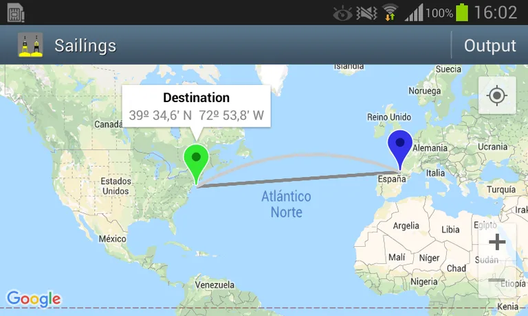
The app plots on a Google map the route between a departure and a destination point, using the following sailings:
- Rhumb line (loxodromic).
- Great Circle (orthodromic).
And calculates:
- Course & distance.
- Waypoints of the great circle route.
- Save between Rhumb line and Great Circle route.
- Nodes and vertices of the Great Circle.
It also plots the entire Great Circle.
OPERATION
1 - Long click 1: adds the departure point
2 - Long click 2: adds the destination point and plots RL & GC
3 - Tap the Mark to see the information
4- [Output]
- GC course C and distance D
- Save between RL & GC
- Waypoints of the GC route
- Vertices and nodes of the GC
WARNING not for live navigation. Sailings App is a useful calculator for navigation.
User interface:
- Zoom buttons +/-
- Map types: normal, terrain and satellite
- GPS location. ("Location" App permission must be allowed. Switch on you GPS, and then automatic location detection is possible).
See App help for more details.
Required features
- Faketouch android.hardware.faketouch
- Location android.hardware.location
- Location Gps android.hardware.location.gps
Permissions (6)
Sailings requests the following Android permissions:
- Access Coarse Location android.permission.ACCESS_COARSE_LOCATION
- Access Fine Location android.permission.ACCESS_FINE_LOCATION
- Access Network State android.permission.ACCESS_NETWORK_STATE
- Internet android.permission.INTERNET
- Providers Gsf Permission Read Gservices com.google.android.providers.gsf.permission.READ_GSERVICES
- Com Sailings Dynamic Receiver Not Exported Permission com.Sailings.DYNAMIC_RECEIVER_NOT_EXPORTED_PERMISSION
