
QField for QGIS
Survey and digitize data in the field with seamless synchronization
OPENGIS.ch · ch.opengis.qfield


UpdatedApr 23, 2026
PublishedNov 14, 2021
Packagech.opengis.qfield
MD5b3d1f8caad080f3aeaf1d579c12f0763
SHA1 (signer)9F:19:98:14:D2:00:D6:B6:D0:B6:11:54:86:36:FF:1E:F5:43:08:AD
Signed byCN=Marco Bernasocchi, O=OPENGIS.ch LLC, L=Sagogn, ST=GR, C=CH
Architecturesx86-64
Malware scanTRUSTED
Websitehttp://www.qfield.org/
Contact[email protected]
Privacy policyView
What's new
Find out what's new on https://github.com/opengisch/QField/releases/tag/v4.1.9
Description
QField – Professional GIS Data Collection Made Easy
QField is the ultimate mobile app for efficient, professional-grade GIS fieldwork. Built on the power of QGIS, it brings fully configured GIS projects to your fingertips—online or fully offline.
🔄 Seamless Cloud Synchronization
Collaborate in real-time with QFieldCloud—sync data and projects effortlessly between the field and office, even in remote areas. Changes made offline are stored and automatically synced when connectivity is restored.
While QFieldCloud provides the most seamless experience, users are free to work through their preferred methods. QField supports loading data via USB, email, downloads, or SD card.
📡 High-Precision GNSS Support
Capture accurate data using your device’s internal GPS or connect external GNSS receivers via Bluetooth, TCP, UDP, or mock location.
🗺️ Key Features:
• Supports .qgs, .qgz, and embedded QGIS projects
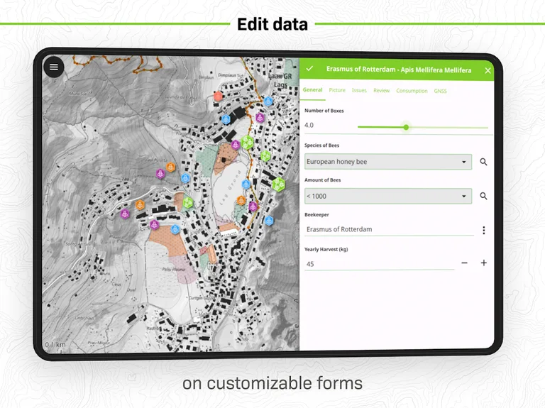
• Custom forms, map themes, and print layouts
• Real-time GPS tracking with altitude, accuracy, and direction
• Offline editing of spatial data anywhere
• Sync projects and updates with QFieldCloud (optional)
📦 Supported Formats:
Vector: GeoPackage, SpatiaLite, GeoJSON, KML, GPX, Shapefiles
Raster: GeoTIFF, Geospatial PDF, WEBP, JPEG2000
🔧 Want to customize or add new features?
Contact us at https://www.opengis.ch/contact/
🔐 Permissions
QField may request location access to display your position and collect spatial data. External GNSS is fully supported for high-precision needs.
❓ Questions or Issues?
Report bugs or request features at: https://qfield.org/issues
QField is the ultimate mobile app for efficient, professional-grade GIS fieldwork. Built on the power of QGIS, it brings fully configured GIS projects to your fingertips—online or fully offline.
🔄 Seamless Cloud Synchronization
Collaborate in real-time with QFieldCloud—sync data and projects effortlessly between the field and office, even in remote areas. Changes made offline are stored and automatically synced when connectivity is restored.
While QFieldCloud provides the most seamless experience, users are free to work through their preferred methods. QField supports loading data via USB, email, downloads, or SD card.
📡 High-Precision GNSS Support
Capture accurate data using your device’s internal GPS or connect external GNSS receivers via Bluetooth, TCP, UDP, or mock location.
🗺️ Key Features:
• Supports .qgs, .qgz, and embedded QGIS projects
• Custom forms, map themes, and print layouts
• Real-time GPS tracking with altitude, accuracy, and direction
• Offline editing of spatial data anywhere
• Sync projects and updates with QFieldCloud (optional)
📦 Supported Formats:
Vector: GeoPackage, SpatiaLite, GeoJSON, KML, GPX, Shapefiles
Raster: GeoTIFF, Geospatial PDF, WEBP, JPEG2000
🔧 Want to customize or add new features?
Contact us at https://www.opengis.ch/contact/
🔐 Permissions
QField may request location access to display your position and collect spatial data. External GNSS is fully supported for high-precision needs.
❓ Questions or Issues?
Report bugs or request features at: https://qfield.org/issues
Required features
- Faketouch android.hardware.faketouch
- Location android.hardware.location
Permissions (18)
QField for QGIS requests the following Android permissions:
- Access Coarse Location android.permission.ACCESS_COARSE_LOCATION
- Access Fine Location android.permission.ACCESS_FINE_LOCATION
- Access Media Location android.permission.ACCESS_MEDIA_LOCATION
- Access Network State android.permission.ACCESS_NETWORK_STATE
- Bluetooth Connect android.permission.BLUETOOTH_CONNECT
- Bluetooth Scan android.permission.BLUETOOTH_SCAN
- Camera android.permission.CAMERA
- Flashlight android.permission.FLASHLIGHT
- Foreground Service android.permission.FOREGROUND_SERVICE
- Foreground Service Data Sync android.permission.FOREGROUND_SERVICE_DATA_SYNC
- Foreground Service Location android.permission.FOREGROUND_SERVICE_LOCATION
- Internet android.permission.INTERNET
- Nfc android.permission.NFC
- Post Notifications android.permission.POST_NOTIFICATIONS
- Record Audio android.permission.RECORD_AUDIO
- Vibrate android.permission.VIBRATE
- Wake Lock android.permission.WAKE_LOCK
- Ch Opengis Qfield Dynamic Receiver Not Exported Permission ch.opengis.qfield.DYNAMIC_RECEIVER_NOT_EXPORTED_PERMISSION