
PPM Commander - GPS status
GNSS/GPS status - mock location - NTRIP client
PilaBlu · de.pilablu.gnsscommander


UpdatedJun 13, 2021
PublishedJun 13, 2021
Packagede.pilablu.gnsscommander
MD566379b2237ed8a7bab77c07aa04cf65a
SHA1 (signer)33:AC:35:D6:11:3B:7D:5D:45:B7:08:64:5F:5C:C7:31:54:73:0C:5F
Signed byCN=Markus Hoffmann, OU=Developement, O=PilaBlu, L=Stuttgart, ST=BaW?, C=DE
Architecturesx86, x86-64, armeabi-v7a, arm64-v8a
Malware scanTRUSTED
Contact[email protected]
Privacy policyView
What's new
+ Add extra info to mocking location
Description
Connect your
by
. Route the GPS position as
to any navigation app on your phone or tablet.
Show
like position, height, accuracy, satellites, velocity, etc.
You can forward
to your high accuracy external device. RTCM data is loaded from the internet by the internal NTRIP client.
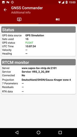
The app ist completely free with the exception of the NTRIP-RTCM feature. If you want to forward RTK data from your data provider (e.g. land surveying office) to the external GPS antenna, please license the app. You can fully test the NTRIP feature in advance within the 30 days trial period. You can view received RTCM message-types and coordinate-projection-parameters of the RTK data on the RTCM monitor page.
The PPM Commander can transform WGS84 coordinates into a local coordinate system like "Gauß-Krueger or UTM" for germany. Additionally you can set a fixed offset to the transformation for further improvement of the calculated local coordinate. If you allow mock locations in the developer options of your android device you can use the position of the external receiver in any application. The preferred way to process the external GPS position in other apps without using "mock locations" is implementing a simple ContentObserver. You can even get the transformed local coordinate and additional informations about the GPS status by using the app as content-provider.
By activating the "mocking" feature (get the position of your external GPS antenna into android) you can use this app for any other navigation-app or for geo-tagging.
+ GPS Status
+ Satellite list & Sky-Plot with subsystems like GPS, Glonass or Galileo
+ Coordinate-Transformation into local coordinate system
+ Mock location provider (e.g. use your external device for navigation)
+ Log all received NMEA data
+ RTK correction data over internet (NTRIP client)
+ RTCM monitor
+ Android "content provider" feature to access all status data
by
. Route the GPS position as
to any navigation app on your phone or tablet.
Show
like position, height, accuracy, satellites, velocity, etc.
You can forward
to your high accuracy external device. RTCM data is loaded from the internet by the internal NTRIP client.
The app ist completely free with the exception of the NTRIP-RTCM feature. If you want to forward RTK data from your data provider (e.g. land surveying office) to the external GPS antenna, please license the app. You can fully test the NTRIP feature in advance within the 30 days trial period. You can view received RTCM message-types and coordinate-projection-parameters of the RTK data on the RTCM monitor page.
The PPM Commander can transform WGS84 coordinates into a local coordinate system like "Gauß-Krueger or UTM" for germany. Additionally you can set a fixed offset to the transformation for further improvement of the calculated local coordinate. If you allow mock locations in the developer options of your android device you can use the position of the external receiver in any application. The preferred way to process the external GPS position in other apps without using "mock locations" is implementing a simple ContentObserver. You can even get the transformed local coordinate and additional informations about the GPS status by using the app as content-provider.
By activating the "mocking" feature (get the position of your external GPS antenna into android) you can use this app for any other navigation-app or for geo-tagging.
+ GPS Status
+ Satellite list & Sky-Plot with subsystems like GPS, Glonass or Galileo
+ Coordinate-Transformation into local coordinate system
+ Mock location provider (e.g. use your external device for navigation)
+ Log all received NMEA data
+ RTK correction data over internet (NTRIP client)
+ RTCM monitor
+ Android "content provider" feature to access all status data
Required features
- Bluetooth android.hardware.bluetooth
- Faketouch android.hardware.faketouch
- Location android.hardware.location
Permissions (11)
PPM Commander - GPS status requests the following Android permissions:
- Access Coarse Location android.permission.ACCESS_COARSE_LOCATION
- Access Fine Location android.permission.ACCESS_FINE_LOCATION
- Access Mock Location android.permission.ACCESS_MOCK_LOCATION
- Access Network State android.permission.ACCESS_NETWORK_STATE
- Bluetooth android.permission.BLUETOOTH
- Bluetooth Admin android.permission.BLUETOOTH_ADMIN
- Foreground Service android.permission.FOREGROUND_SERVICE
- Internet android.permission.INTERNET
- Read External Storage android.permission.READ_EXTERNAL_STORAGE
- Write External Storage android.permission.WRITE_EXTERNAL_STORAGE
- Providers Gsf Permission Read Gservices com.google.android.providers.gsf.permission.READ_GSERVICES