


UpdatedApr 22, 2026
PublishedApr 20, 2021
Packagecom.nextgis.mobile
MD5762c9410f61f28f168ae8b7fd82183b2
SHA1 (signer)98:7C:B6:CF:A5:A2:14:1C:D1:0F:8E:13:AD:2A:50:BA:9B:D8:8F:2E
Signed byCN=Dmitry Baryshnikov, O=NextGIS, L=Moscow, ST=Russia, C=RU
Architecturesx86, x86-64, armeabi-v7a, arm64-v8a
Malware scanTRUSTED
Contact[email protected]
Privacy policyView
What's new
Demo projects support. Fixing problems with multipolygons, GPX export and data editing.
Description
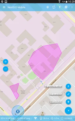
NextGIS Mobile is a geographic information system for your mobile device that can:
- show multi-layer map (layers can come from online and offline sources)
- change visibility and layers order
- navigate the map (panning, zoom in, zoom out)
- edit vector data (both geometries and attributes) online and offline
- record tracks
- show coordinates, speed, elevation etc.
- show multi-layer map (layers can come from online and offline sources)
- change visibility and layers order
- navigate the map (panning, zoom in, zoom out)
- edit vector data (both geometries and attributes) online and offline
- record tracks
- show coordinates, speed, elevation etc.
Required features
- Faketouch android.hardware.faketouch
- Location android.hardware.location
Permissions (24)
NextGIS Mobile requests the following Android permissions:
- Access Background Location android.permission.ACCESS_BACKGROUND_LOCATION
- Access Coarse Location android.permission.ACCESS_COARSE_LOCATION
- Access Fine Location android.permission.ACCESS_FINE_LOCATION
- Access Network State android.permission.ACCESS_NETWORK_STATE
- Access Wifi State android.permission.ACCESS_WIFI_STATE
- Authenticate Accounts android.permission.AUTHENTICATE_ACCOUNTS
- Foreground Service android.permission.FOREGROUND_SERVICE
- Foreground Service Data Sync android.permission.FOREGROUND_SERVICE_DATA_SYNC
- Foreground Service Location android.permission.FOREGROUND_SERVICE_LOCATION
- Get Accounts android.permission.GET_ACCOUNTS
- Internet android.permission.INTERNET
- Manage Accounts android.permission.MANAGE_ACCOUNTS
- Post Notifications android.permission.POST_NOTIFICATIONS
- Read External Storage android.permission.READ_EXTERNAL_STORAGE
- Read Sync Settings android.permission.READ_SYNC_SETTINGS
- Read Sync Stats android.permission.READ_SYNC_STATS
- Receive Boot Completed android.permission.RECEIVE_BOOT_COMPLETED
- Request Ignore Battery Optimizations android.permission.REQUEST_IGNORE_BATTERY_OPTIMIZATIONS
- Use Credentials android.permission.USE_CREDENTIALS
- Vibrate android.permission.VIBRATE
- Wake Lock android.permission.WAKE_LOCK
- Write Sync Settings android.permission.WRITE_SYNC_SETTINGS
- Gms Permission Ad Id com.google.android.gms.permission.AD_ID
- Com Nextgis Mobile Dynamic Receiver Not Exported Permission com.nextgis.mobile.DYNAMIC_RECEIVER_NOT_EXPORTED_PERMISSION