
Navitel Navigator GPS & Maps
Popular offline GPS navigation with detailed maps of more than 60 countries.
Center of Navigation Technologies · com.navitel


UpdatedNov 15, 2025
PublishedJun 4, 2020
Packagecom.navitel
MD5bedd320f4085f9990778d7a0e93e4a6f
SHA1 (signer)77:5A:DF:E5:47:34:FF:4E:C4:40:04:04:42:EC:3B:2C:39:B7:5F:AF
Signed byCN=Unknown, OU=R&D, O=JSC CNT, L=Moscow, ST=Unknown, C=RU
Architecturesx86-64, armeabi-v7a, arm64-v8a
Malware scanTRUSTED
Websitehttp://www.navitel.cz/
Contact[email protected]
Privacy policyView
What's new
- Fixed route disappearance issue
- Fixed crashes causing app to close
- Improved translations
- Fixed crashes causing app to close
- Improved translations
Description
ADVANTAGES
• Modern user-friendly interface.
• Offline maps. To work with the program and maps, you do not need the Internet: savings in roaming and independence from the quality of communication in the regions.
• Navigation maps with a high level of detail.
• Easy and convenient POI search by category.
• Visual and voice guidance along the route.
• Information about radars, speed cameras and road restrictions.
• The ability to display information on the windshield of the car — HUD (Head-Up Display)
• Android Auto support.
• Navigation maps of 66 countries are available.
SPECIAL FEATURES
• Fast route calculation. Instant calculation and routing of any length and complexity.
• Three alternative routes with distance and travel time information.
• Navitel.Traffic — information about traffic jams in real time throughout the maps.
• Navitel.Events — information about speed cameras, road accidents, road works and incidents marked on the map by users of the program.
• SpeedCam warnings —information about radars, speed cameras and road restrictions.
• 3D Maps — three-dimensional maps with support for textures and display of building heights.
• 3D Road interchanges — display of multi-level road interchanges in 3D mode.
• Lane Assist — route calculations taking multilane traffic into account and visual prompts while following the route.
• Turn-by-turn voice guidance while moving along the route.
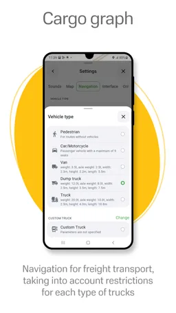
• Cargo graph — building routes considering road signs for cars from 3.5 to 40+ tons.
• Unlimited number of waypoints when building a route. Convenient route planning with an unlimited number of waypoints.
• Customizable user interface. Ability to adapt the program interface and map display mode for your own needs.
OFFLINE MAPS FOR DOWNLOAD
Austria, Azerbaijan, Albania, Andorra, Argentina, Armenia, Belarus, Belgium, Bulgaria, Bosnia and Herzegovina, Great Britain, Hungary, Germany, Gibraltar, Greece, Georgia, Denmark, Iran, Iceland, Spain, Kazakhstan, Cyprus, Kyrgyzstan, Latvia, Lithuania, Liechtenstein, Luxembourg, Maldives, Moldova, Monaco, Mongolia, the Netherlands, Norway, Isle of Man, Pakistan, Poland, Portugal, Romania, North Macedonia, Serbia, Slovakia, Slovenia, Tajikistan, Turkmenistan Turkey, Uzbekistan, Philippines, Finland, France, Croatia, Montenegro, Czech Republic, Switzerland, Sweden, Estonia.
If you have any questions contact us: [email protected].
We will be happy to help you.
• Modern user-friendly interface.
• Offline maps. To work with the program and maps, you do not need the Internet: savings in roaming and independence from the quality of communication in the regions.
• Navigation maps with a high level of detail.
• Easy and convenient POI search by category.
• Visual and voice guidance along the route.
• Information about radars, speed cameras and road restrictions.
• The ability to display information on the windshield of the car — HUD (Head-Up Display)
• Android Auto support.
• Navigation maps of 66 countries are available.
SPECIAL FEATURES
• Fast route calculation. Instant calculation and routing of any length and complexity.
• Three alternative routes with distance and travel time information.
• Navitel.Traffic — information about traffic jams in real time throughout the maps.
• Navitel.Events — information about speed cameras, road accidents, road works and incidents marked on the map by users of the program.
• SpeedCam warnings —information about radars, speed cameras and road restrictions.
• 3D Maps — three-dimensional maps with support for textures and display of building heights.
• 3D Road interchanges — display of multi-level road interchanges in 3D mode.
• Lane Assist — route calculations taking multilane traffic into account and visual prompts while following the route.
• Turn-by-turn voice guidance while moving along the route.
• Cargo graph — building routes considering road signs for cars from 3.5 to 40+ tons.
• Unlimited number of waypoints when building a route. Convenient route planning with an unlimited number of waypoints.
• Customizable user interface. Ability to adapt the program interface and map display mode for your own needs.
OFFLINE MAPS FOR DOWNLOAD
Austria, Azerbaijan, Albania, Andorra, Argentina, Armenia, Belarus, Belgium, Bulgaria, Bosnia and Herzegovina, Great Britain, Hungary, Germany, Gibraltar, Greece, Georgia, Denmark, Iran, Iceland, Spain, Kazakhstan, Cyprus, Kyrgyzstan, Latvia, Lithuania, Liechtenstein, Luxembourg, Maldives, Moldova, Monaco, Mongolia, the Netherlands, Norway, Isle of Man, Pakistan, Poland, Portugal, Romania, North Macedonia, Serbia, Slovakia, Slovenia, Tajikistan, Turkmenistan Turkey, Uzbekistan, Philippines, Finland, France, Croatia, Montenegro, Czech Republic, Switzerland, Sweden, Estonia.
If you have any questions contact us: [email protected].
We will be happy to help you.
Required features
- Faketouch android.hardware.faketouch
- Location android.hardware.location
- Microphone android.hardware.microphone
- Wifi android.hardware.wifi
Permissions (17)
Navitel Navigator GPS & Maps requests the following Android permissions:
- Access Coarse Location android.permission.ACCESS_COARSE_LOCATION
- Access Fine Location android.permission.ACCESS_FINE_LOCATION
- Access Network State android.permission.ACCESS_NETWORK_STATE
- Change Wifi State android.permission.CHANGE_WIFI_STATE
- Foreground Service android.permission.FOREGROUND_SERVICE
- Foreground Service Location android.permission.FOREGROUND_SERVICE_LOCATION
- Internet android.permission.INTERNET
- Local Mac Address android.permission.LOCAL_MAC_ADDRESS
- Post Notifications android.permission.POST_NOTIFICATIONS
- Read Privileged Phone State android.permission.READ_PRIVILEGED_PHONE_STATE
- Record Audio android.permission.RECORD_AUDIO
- Wake Lock android.permission.WAKE_LOCK
- Androidx Car App Access Surface androidx.car.app.ACCESS_SURFACE
- Androidx Car App Navigation Templates androidx.car.app.NAVIGATION_TEMPLATES
- Com Android Launcher Permission Install Shortcut com.android.launcher.permission.INSTALL_SHORTCUT
- Com Android Vending Billing com.android.vending.BILLING
- Com Navitel Dynamic Receiver Not Exported Permission com.navitel.DYNAMIC_RECEIVER_NOT_EXPORTED_PERMISSION