
Nautical Info Service Croatia
For sailors on Adriatic sea. Weather forecast, Navigation information, Contacts
Ministarstvo pomorstva, prometa i infrastrukture · hr.mppi.nis


UpdatedApr 2, 2026
PublishedDec 15, 2022
Packagehr.mppi.nis
MD551d31bd688b654fb5118894cdc00ab9e
SHA1 (signer)AA:23:90:F2:A9:B0:3A:0C:C0:08:BF:AB:A9:7F:7A:F7:6D:0A:26:70
Signed byO=Ministarstvo pomorstva prometa i infrastrukture
Architecturesarmeabi-v7a, arm64-v8a
Malware scanTRUSTED
Websitehttp://www.mppi.hr
Contact[email protected]
Privacy policyView
What's new
Performance improvement.
Description
Nautical Information Service (nIS) is a free bilingual application for smartphones, intended for owners of yachts and boats, fishermen, divers, swimmers and other people who spend time on the coast and at sea. nIS was developed so that users could provide substantial and detailed information to the local harbormaster's offices and other services for navigation safety, prevention of marine pollution, and especially to search and rescue services, in a quick and simple way. nIS can also provide users all the necessary information important for their safety, at any time and at every place.
nIS enables users to follow official weather forecast and have easy access to important navigation rules and information.
Contents of the nIS application:
• weather forecast for mariners (air temperature, wind speed and direction, air pressure, waves, radar cloud coverage)
• navigation rules (vessel equipment, order in ports and at sea, avoiding collision at sea, marine environment protection, information for foreign vessels, divers and swimmers, radio service and radio notices, maritime marks)
• public services contacts (search and rescue, harbormaster's offices, hyperbaric chamber, commercial salvage, consulates, medical institutions, emergency services, VTS service, coastal radio stations)
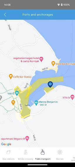
• ports and anchorages (marines, nautical anchorages, petrol stations, border crossings)
nIS enables users to follow official weather forecast and have easy access to important navigation rules and information.
Contents of the nIS application:
• weather forecast for mariners (air temperature, wind speed and direction, air pressure, waves, radar cloud coverage)
• navigation rules (vessel equipment, order in ports and at sea, avoiding collision at sea, marine environment protection, information for foreign vessels, divers and swimmers, radio service and radio notices, maritime marks)
• public services contacts (search and rescue, harbormaster's offices, hyperbaric chamber, commercial salvage, consulates, medical institutions, emergency services, VTS service, coastal radio stations)
• ports and anchorages (marines, nautical anchorages, petrol stations, border crossings)
Required features
- Faketouch android.hardware.faketouch
- Location android.hardware.location
- Wifi android.hardware.wifi
Permissions (33)
Nautical Info Service Croatia requests the following Android permissions:
- Access Coarse Location android.permission.ACCESS_COARSE_LOCATION
- Access Fine Location android.permission.ACCESS_FINE_LOCATION
- Access Network State android.permission.ACCESS_NETWORK_STATE
- Access Wifi State android.permission.ACCESS_WIFI_STATE
- Change Wifi State android.permission.CHANGE_WIFI_STATE
- Download Without Notification android.permission.DOWNLOAD_WITHOUT_NOTIFICATION
- Foreground Service android.permission.FOREGROUND_SERVICE
- Internet android.permission.INTERNET
- Post Notifications android.permission.POST_NOTIFICATIONS
- Read App Badge android.permission.READ_APP_BADGE
- Receive Boot Completed android.permission.RECEIVE_BOOT_COMPLETED
- Vibrate android.permission.VIBRATE
- Wake Lock android.permission.WAKE_LOCK
- Write External Storage android.permission.WRITE_EXTERNAL_STORAGE
- Com Anddoes Launcher Permission Update Count com.anddoes.launcher.permission.UPDATE_COUNT
- C2dm Permission Receive com.google.android.c2dm.permission.RECEIVE
- Finsky Permission Bind Get Install Referrer Service com.google.android.finsky.permission.BIND_GET_INSTALL_REFERRER_SERVICE
- Com Htc Launcher Permission Read Settings com.htc.launcher.permission.READ_SETTINGS
- Com Htc Launcher Permission Update Shortcut com.htc.launcher.permission.UPDATE_SHORTCUT
- Com Huawei Android Launcher Permission Change Badge com.huawei.android.launcher.permission.CHANGE_BADGE
- Com Huawei Android Launcher Permission Read Settings com.huawei.android.launcher.permission.READ_SETTINGS
- Com Huawei Android Launcher Permission Write Settings com.huawei.android.launcher.permission.WRITE_SETTINGS
- Com Majeur Launcher Permission Update Badge com.majeur.launcher.permission.UPDATE_BADGE
- Com Oppo Launcher Permission Read Settings com.oppo.launcher.permission.READ_SETTINGS
- Com Oppo Launcher Permission Write Settings com.oppo.launcher.permission.WRITE_SETTINGS
- Com Sec Android Provider Badge Permission Read com.sec.android.provider.badge.permission.READ
- Com Sec Android Provider Badge Permission Write com.sec.android.provider.badge.permission.WRITE
- Com Sonyericsson Home Permission Broadcast Badge com.sonyericsson.home.permission.BROADCAST_BADGE
- Com Sonymobile Home Permission Provider Insert Badge com.sonymobile.home.permission.PROVIDER_INSERT_BADGE
- Hr Mppi Nis Dynamic Receiver Not Exported Permission hr.mppi.nis.DYNAMIC_RECEIVER_NOT_EXPORTED_PERMISSION
- Hr Mppi Nis Permission C2d Message hr.mppi.nis.permission.C2D_MESSAGE
- Me Everything Badger Permission Badge Count Read me.everything.badger.permission.BADGE_COUNT_READ
- Me Everything Badger Permission Badge Count Write me.everything.badger.permission.BADGE_COUNT_WRITE
