
Martley Rocks
Interactive 3D model of Martley geology.
BrooksDesigns · air.uk.co.brooksdesigns.MartleyRocks


UpdatedAug 27, 2024
PublishedMar 27, 2023
Packageair.uk.co.brooksdesigns.MartleyRocks
MD582197f3967938777eb4e7dc8114ab287
SHA1 (signer)F6:97:67:00:CC:46:FE:B5:6F:3B:D4:82:39:51:36:FB:65:D2:D6:4A
Signed byCN=BrooksDesigns, OU=Development, O=BrooksDesigns, C=GB
Architecturesx86
Malware scanTRUSTED
Websitehttp://brooksdesigns.co.uk
Contact[email protected]
What's new
Android update
Description
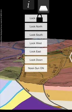
Interact with the fascinating and exceptional geology of Martley, Worcestershire, England, with this app which provides an interactive 3D model of the area. View the terrain by moving around the model with touch gestures or tilting your device.
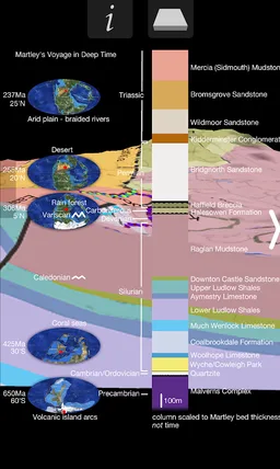
Interpretation of past environments and the ‘Voyage of Martley’ from the near the South Pole to 52’N over 700 million years of Earth history.
Touching the map provides information about the geology of your location.
Includes the routes for all Martley GeoTrails plus the Geopark Way, with of course GPS guidance of your current position on the path.
Special section for Martley Rocks site, which includes interactive map based on latest trenching work, with photos ‘from the trenches’ and interpretation along the entire length of the permanent trench.
2D map of geology and trails from Abberley to The Talbot, with photo hot spots and cross-section.
Sections for the Chantry School Rock Garden, The Nubbins, Worcestershire Basin, GeoVillage & TVGS and ‘Where is Martley’.
Required features
- Faketouch android.hardware.faketouch
- Location android.hardware.location
Permissions (7)
Martley Rocks requests the following Android permissions:
- Access Coarse Location android.permission.ACCESS_COARSE_LOCATION
- Access Fine Location android.permission.ACCESS_FINE_LOCATION
- Foreground Service android.permission.FOREGROUND_SERVICE
- Internet android.permission.INTERNET
- Receive Boot Completed android.permission.RECEIVE_BOOT_COMPLETED
- Vibrate android.permission.VIBRATE
- Write External Storage android.permission.WRITE_EXTERNAL_STORAGE