
Mapit GIS - NTRIP Client
Simple tool to get RTK corrected coordinates into Mapit and log RAW GNSS data.
Mapit GIS LTD · com.osedok.ntripclient


UpdatedJul 16, 2025
PublishedMar 14, 2021
Packagecom.osedok.ntripclient
MD529643810d7039cd11011650b0126d6a1
SHA1 (signer)80:1A:89:DD:34:58:08:26:6E:FF:E9:85:61:CE:A4:8F:37:62:48:E0
Signed byCN=Android, OU=Android, O=Google Inc., L=Mountain View, ST=California, C=US
Architecturesx86, armeabi-v7a
Malware scanTRUSTED
Websitehttp://mapit-gis.com
Contact[email protected]
What's new
CHANGE: Update some urls templates to comply with Google security policy.
Description
This software is provided “AS IS” without any warranties of any kind so please be careful, especially if using it in any kind of real-time application.
Mapit NTRIP Client is fully compatible with Mapit GIS Data Collector version 6.0.0 and higher (available soon in the store).
You can use any RTKLIB compliant GNSS with raw output connected via USB (ACM/PL2303/FTDI), Bluetooth, TCPIP or NTRIP.
To use this application with Mapit GIS Data Collector:
1. Install Mapit 6.0.0 or higher.
2. Instal Mapit NTRIP Client
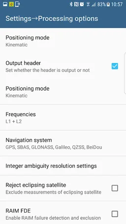
3. In Mapit go to settings->External GNSS and enable NTRIP Client
4. Set your input streams and start the RTK service
More detailed guide is available on our website:
http://mapit-gis.com/mapit-gis-ntrip-client/
NOTE: This application cannot process "standard" GPS data like those embedded into your phone or tablet. It has been tested with some external GNSS receivers but you need to determine yourself if this app suites your needs.
This application is using RTKLIB library and you need to have a supported GNSS receiver to be able to use it with this application. Before buying subscription please do ensure that your receiver is working well with the app - 7 days FREE Trial is available so you can test the application and see if it meets your needs.
The code for this application is based on RtkGps+ fromRonan LE MEILLAT and Alexey Illarionov. You'll find the original license in the "About/Legacy Info" screen. Thanks to all contributors to respect this original license clause.
This software is a port of RTKLIB 2.4.2p9 developed by Tomoki Takasu (http://www.rtklib.com).
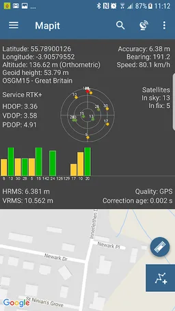
This application can compute precise GPS positions using RTKLIB algorithms (RTK or PPP) but for this you need a supported external GPS/GNSS with raw carrier phase output.
Mapit NTRIP Client is fully compatible with Mapit GIS Data Collector version 6.0.0 and higher (available soon in the store).
You can use any RTKLIB compliant GNSS with raw output connected via USB (ACM/PL2303/FTDI), Bluetooth, TCPIP or NTRIP.
To use this application with Mapit GIS Data Collector:
1. Install Mapit 6.0.0 or higher.
2. Instal Mapit NTRIP Client
3. In Mapit go to settings->External GNSS and enable NTRIP Client
4. Set your input streams and start the RTK service
More detailed guide is available on our website:
http://mapit-gis.com/mapit-gis-ntrip-client/
NOTE: This application cannot process "standard" GPS data like those embedded into your phone or tablet. It has been tested with some external GNSS receivers but you need to determine yourself if this app suites your needs.
This application is using RTKLIB library and you need to have a supported GNSS receiver to be able to use it with this application. Before buying subscription please do ensure that your receiver is working well with the app - 7 days FREE Trial is available so you can test the application and see if it meets your needs.
The code for this application is based on RtkGps+ fromRonan LE MEILLAT and Alexey Illarionov. You'll find the original license in the "About/Legacy Info" screen. Thanks to all contributors to respect this original license clause.
This software is a port of RTKLIB 2.4.2p9 developed by Tomoki Takasu (http://www.rtklib.com).
This application can compute precise GPS positions using RTKLIB algorithms (RTK or PPP) but for this you need a supported external GPS/GNSS with raw carrier phase output.
Required features
- Faketouch android.hardware.faketouch
- Location android.hardware.location
- Wifi android.hardware.wifi
Permissions (13)
Mapit GIS - NTRIP Client requests the following Android permissions:
- Access Coarse Location android.permission.ACCESS_COARSE_LOCATION
- Access Fine Location android.permission.ACCESS_FINE_LOCATION
- Access Mock Location android.permission.ACCESS_MOCK_LOCATION
- Access Network State android.permission.ACCESS_NETWORK_STATE
- Access Wifi State android.permission.ACCESS_WIFI_STATE
- Bluetooth android.permission.BLUETOOTH
- Bluetooth Admin android.permission.BLUETOOTH_ADMIN
- Foreground Service android.permission.FOREGROUND_SERVICE
- Internet android.permission.INTERNET
- Usb Permission android.permission.USB_PERMISSION
- Wake Lock android.permission.WAKE_LOCK
- Write External Storage android.permission.WRITE_EXTERNAL_STORAGE
- Com Android Vending Billing com.android.vending.BILLING