


UpdatedOct 31, 2024
PublishedAug 13, 2019
Packagecom.karnadi.lindu
MD593214e8e454e452f49e466bf9b8fc604
SHA1 (signer)79:75:88:EA:21:AC:7E:FC:BB:48:85:A3:93:B1:AA:E3:1A:44:A2:27
Signed byCN=Ujang Karnadi, OU=Soft, O=Karnadi, L=Klaten, ST=Jawa Tengah, C=62
Malware scanUNKNOWN
Contact[email protected]
What's new
Minor update and bug fix
Description
Lindu is an earthquake report app that use USGS (United States Geological Survey) earthquake API, you can search an earthquake with minimal magnitude, maximal magnitude, start date, and end date. Including a map with fault line. Lindu will show you world earthquake, earthquake that happen around the world.
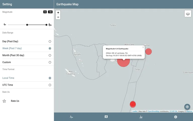
With Lindu you can Search worldwide earthquake with specific magnitude range from 1 to 10. You can search worldwide earthquake with specific range date, you can see an earthquake from the past like earthquake that happen 2 year ago or 3 year ago. You can specify the time format to display, UTC or your local timezone. You can sort earthquake list with "oldest earthquake", "latest earthquake" , "largest magnitude", "smallest magnitude". Lindu have an interactive map powered by leafletjs and mapbox with fault line.
It is also have a statistic page that show a statistic earthquake for significant earthquake last month (past 30 days). there is also a counter for earthquake that count how many time earthquake happen in a day, week, month and year. Lindu also show you a detail earthquake event page if you press on one of the earthquake list.
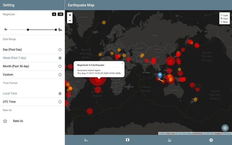
if you don't like the map color, you can always change it to dark, light or blue. it is also show your current location, if there is an earthquake that close enough to you, the map will draw a line from your current position/location to the 5 nearest earthquake.
Features:
-Simple, easy to use.
-Custom Search earthquake,
-Search by minimal and maximal magnitude
-Search by start date and end date
-Different color alert each magnitude,
-Relative time,
-Choose between Local Timezone or UTC timezone
-Sort earthquake list by magnitude(Largest, Smallest) and date(Newest, Oldest )
-Interactive map with fault line.
-Earthquake detail,
-Visit USGS earthquake event
-Locate your position
-Significant earthquake past 30 days,
-Earthquake counter for today, this week, this month and this year
Feature to be added:
-Earthquake news,
-Get nearest earthquake location
Credit:
pulse icon by Thomas Uebe from the Noun Project
With Lindu you can Search worldwide earthquake with specific magnitude range from 1 to 10. You can search worldwide earthquake with specific range date, you can see an earthquake from the past like earthquake that happen 2 year ago or 3 year ago. You can specify the time format to display, UTC or your local timezone. You can sort earthquake list with "oldest earthquake", "latest earthquake" , "largest magnitude", "smallest magnitude". Lindu have an interactive map powered by leafletjs and mapbox with fault line.
It is also have a statistic page that show a statistic earthquake for significant earthquake last month (past 30 days). there is also a counter for earthquake that count how many time earthquake happen in a day, week, month and year. Lindu also show you a detail earthquake event page if you press on one of the earthquake list.
if you don't like the map color, you can always change it to dark, light or blue. it is also show your current location, if there is an earthquake that close enough to you, the map will draw a line from your current position/location to the 5 nearest earthquake.
Features:
-Simple, easy to use.
-Custom Search earthquake,
-Search by minimal and maximal magnitude
-Search by start date and end date
-Different color alert each magnitude,
-Relative time,
-Choose between Local Timezone or UTC timezone
-Sort earthquake list by magnitude(Largest, Smallest) and date(Newest, Oldest )
-Interactive map with fault line.
-Earthquake detail,
-Visit USGS earthquake event
-Locate your position
-Significant earthquake past 30 days,
-Earthquake counter for today, this week, this month and this year
Feature to be added:
-Earthquake news,
-Get nearest earthquake location
Credit:
pulse icon by Thomas Uebe from the Noun Project
Required features
- Location android.hardware.location
- Location Gps android.hardware.location.gps
- Location Network android.hardware.location.network
- Touchscreen android.hardware.touchscreen
Permissions (4)
Lindu - USGS Earthquake Report requests the following Android permissions:
- Access Coarse Location android.permission.ACCESS_COARSE_LOCATION
- Access Fine Location android.permission.ACCESS_FINE_LOCATION
- Access Network State android.permission.ACCESS_NETWORK_STATE
- Internet android.permission.INTERNET