
IcarusRPA
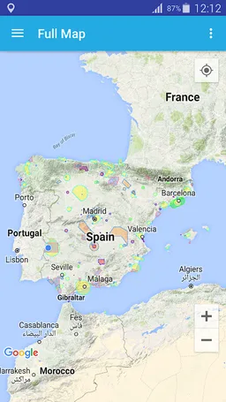
Map where all the aerospace with restrictions to fly a UAV in Spain can be check
SKYDRONEX - DRONEX · com.skydronex.icarusrpa


UpdatedJun 7, 2024
PublishedFeb 19, 2021
Packagecom.skydronex.icarusrpa
MD502fd1c415db95df93d06d2c78ac83c7a
SHA1 (signer)DB:13:17:46:27:35:E9:CC:CB:C9:5A:48:C8:6D:25:9B:84:83:0C:4E
Signed byCN=Ignacio M. Cano Rodilla, OU=Developer, O=SKYDRONEX - DRONEX, L=Badajoz, ST=Badajoz, C=ES
Malware scanTRUSTED
Websitehttp://www.icarusrpa.info
Contact[email protected]
Privacy policyView
What's new
Updated CTR of Madrid
Description
Interactive map where all the aerospace with restrictions to fly a RPAS (UAV) in Spain can be checked.
IcarusRPA is a map based tool that shows graphicly the flying restrictions involving RPAs in Spain. All performance data havce been adapted from the AIP (Aerocraft Information Pbls), which is the basic manual of aerocraft information basic for flying and operatin the RPAs (UAV).
Important information afectting air operations (as Metar or Tafor of any airport -ICAO format-)can be consulted, including the notam of airpots and FIRs. The tool host different meothorologycal maps showing real-time data of windspeed, clouds and rain and the planetary K-index (Kp), used to measure the magnitude of geomagnetic storms.
In this stage of the development of the application, the following information ois shown:
- Restricted areas,
- Hazardous areas,
- Forbidden areas,
- Control zoning (CTR),
- Fotographic flying restricted areas (ZRVF),
- Temporary Segregated areas (TSA),
- Other Protected areas,
- Aeropaces
GIS viewer
Required features
- Faketouch android.hardware.faketouch
- Location android.hardware.location
- Screen Portrait android.hardware.screen.portrait
- Wifi android.hardware.wifi
Permissions (9)
IcarusRPA requests the following Android permissions:
- Access Coarse Location android.permission.ACCESS_COARSE_LOCATION
- Access Fine Location android.permission.ACCESS_FINE_LOCATION
- Access Network State android.permission.ACCESS_NETWORK_STATE
- Access Wifi State android.permission.ACCESS_WIFI_STATE
- Internet android.permission.INTERNET
- Wake Lock android.permission.WAKE_LOCK
- Write External Storage android.permission.WRITE_EXTERNAL_STORAGE
- C2dm Permission Receive com.google.android.c2dm.permission.RECEIVE
- Providers Gsf Permission Read Gservices com.google.android.providers.gsf.permission.READ_GSERVICES