
Hunting Gps Maps, Topo +Trails
Hunt GPS w/ Land Ownership maps, Property Lines, hunt zones & restricted areas
Gps Nautical Charts · com.skiracer.topo_android_market


UpdatedNov 20, 2025
PublishedApr 17, 2021
Packagecom.skiracer.topo_android_market
MD5bbe1356a5d382c2d2005b40dba5d8bf1
SHA1 (signer)DE:A9:2B:91:05:D8:00:85:24:C9:14:C4:A5:DE:27:0D:51:70:10:CC
Signed byCN=Bist LLC, OU=Mobile Apps, O=Bist LLC
Architecturesx86, x86-64, armeabi-v7a, arm64-v8a
Malware scanTRUSTED
Websitehttp://www.toposports.com
Contact[email protected]
Privacy policyView
What's new
- Property line highlights under cursor
- Weather map overlays improvements
- Way Point improvements.
-MAJOR UPDATE
-- Weather Map overlays (Wind, Wave, Pressure, Precipitation, Temperature, Gust)
-- Adjust comfortable values for weather overlays
-- Lake Temperature Maps
-- New search algorithm that shows results as you type in
- Weather map overlays improvements
- Way Point improvements.
-MAJOR UPDATE
-- Weather Map overlays (Wind, Wave, Pressure, Precipitation, Temperature, Gust)
-- Adjust comfortable values for weather overlays
-- Lake Temperature Maps
-- New search algorithm that shows results as you type in
Description
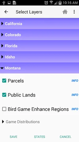
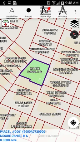
This hunting GPS app provides access to property line maps, parcels & public
lands, land ownership details. Map layers for 50+ states include hunting
zones, restricted areas, possible access areas, state refgues and more.
Vector topo maps with most accurate USGS elevation contours, hiking & biking
trails. Coverage includes all US states.
► Vector Topo Maps
√ Beautiful & detailed Hardware/GPU accelerated vector maps (text stays upright on rotation)
√ Vector USGS contours (Change height to ft or meter).
√ Covers popular hiking & biking trails and paths
► Parcel Maps
√ Includes following ownerhsip attributes (where available)
* Owner name and Owner address
* Site Address
* Parcel ID Total Value
► Hunt Planning maps
√ Possible Public Access
√ Public lands and Parcels
√ Hunting Zones
√ Game Distribution
√ Restricted Ares
√ Portions
► Offline vector maps
√ Easy to download offline topos
► PLSS maps
√ PLSS Townships and Sections (US Wide coverage)
► Custom base maps
√ Switch base maps between vector topos, hybrid satellite imagery and more
►GPS FEATURES
√ Record Tracks
√ Enter or import Waypoints.
√ Auto Follow
* Real Time Track Overlay
* Predicted Path Vector
* Course Up(Text stays upright)
* Speed & Heading
√ Route Assistance With Voice Prompts
* Prompts when approaching a boating route marker
* Continous distance & ETA updates
* Alerts when off route
* Alerts when moving in wrong direction
►ROUTE MANAGEMENT / TRIP PLANNING
√ Create New Route/Edit Existing Routes
√ Move Points
√ Add points to an existing route leg
√ Delete / Rename points
√ Import GPX,KML & KMZ files
√ Plot/Edit Routes
√ Enter Waypoints
√ Share/Export Routes,Tracks&Markers
√ Reverse Routes
► SHARING
* Share tracks/routes/markers on Facebook & Twitter
* Export tracks/routes/markers as compressed GPX files.
► Topo & Trail Maps for National Parks
Detailed topographic trail maps are included for national and state park including::
√ Great Smoky Mountains
√ Grand Canyon
√ Zion
√ Rocky Mountain
√ Yosemite
√ Yellowstone
√ Acadia
√ Olympic
√ Denali
√ Glacier
► Weather Forecasts
Animate weather forecast overlays for the following.
√ Wind Speed and Directions (GFS & ECMWF)
√ Wave Heights (Swell + Wind combined) and Direction(GFS & ECMWF)
√ Pressure (MSL) (GFS & ECMWF)
√ Precipitation
√ Air Temperature (GFS & ECMWF)
√ Gust
√ Lake Temperatures
Comfortable Weather Settings
√ Automatically Highlight Harsh Weather Forecasts
√ Weather settings are customizable based on your preferences.
► Suggested Uses for i-Hunting Topo Maps
√ Hunt Planning & Recon
√ Off trail and On trail hiking
√ Backpacking : Use Topos of National Forests and Wilderness areas with GPS
√ Snow Sports (Snow Shoeing, Skiing, Snowboarding, Snow Mobiling)
√ SAR (Search and Rescue)
The i-Hunting application can turn your phone into full fledged outdoors GPS unit (like Garmin ® or Magellan ® outddor GPS). The app compliments the gear you got from Dick's ® , REI ® , Cabelas ® etc.
Required features
- Faketouch android.hardware.faketouch
- Location android.hardware.location
Permissions (15)
Hunting Gps Maps, Topo +Trails requests the following Android permissions:
- Access Fine Location android.permission.ACCESS_FINE_LOCATION
- Access Network State android.permission.ACCESS_NETWORK_STATE
- Access Wifi State android.permission.ACCESS_WIFI_STATE
- Change Wifi Multicast State android.permission.CHANGE_WIFI_MULTICAST_STATE
- Foreground Service android.permission.FOREGROUND_SERVICE
- Foreground Service Data Sync android.permission.FOREGROUND_SERVICE_DATA_SYNC
- Foreground Service Location android.permission.FOREGROUND_SERVICE_LOCATION
- Internet android.permission.INTERNET
- Post Notifications android.permission.POST_NOTIFICATIONS
- Read Phone State android.permission.READ_PHONE_STATE
- Receive Boot Completed android.permission.RECEIVE_BOOT_COMPLETED
- Wake Lock android.permission.WAKE_LOCK
- Write External Storage android.permission.WRITE_EXTERNAL_STORAGE
- Com Android Vending Billing com.android.vending.BILLING
- Com Android Vending Check License com.android.vending.CHECK_LICENSE
