
GPS Air Navigator
Trial app for VFR real-time GPS Air Navigation
NKSoft · com.nksoftware.gpsairnavigator


UpdatedMar 26, 2025
PublishedMar 26, 2025
Packagecom.nksoftware.gpsairnavigator
MD5bf73250f6fea6a7dc8e26644206e1019
SHA1 (signer)7B:A4:5E:0D:8A:9C:69:AB:17:94:60:18:43:D5:F7:1D:BD:F5:7D:FA
Signed byCN=Nuno Rodrigues, OU=NKSoftware, O=NKSoftware, L=BGC, ST=Portugal, C=PT
Malware scanTRUSTED
Websitehttp://www.nksoft.eu
Contact[email protected]
Privacy policyView
What's new
Support for Czech language
Update of the OpenFlightMaps aeronautical charts (AIRAC 2013)
Significant redesign of the graphical interface and usability
Other small improvements and bug fixes
Update of the OpenFlightMaps aeronautical charts (AIRAC 2013)
Significant redesign of the graphical interface and usability
Other small improvements and bug fixes
Description
GPS Air Navigator is an application for VFR Air Navigation :: Air Nav.
Follow us on https://www.facebook.com/gpsairnavigator!
Main features:
• real-time GPS moving map
• graphical visualization of country air space
• navigation with True or Magnetic North
• High Quality VFR Aeronautical Charts (from Flyermaps.com) for Portugal, Spain, Argentina, Chile, Colombia, Iceland, Uruguay and Venezuela
• free OpenStreetMap maps for all countries
• USA Sectional VFR Charts (generated from FAA VFR Raster Charts)
• WAC and REA Charts from Brazil (thanks to DECEA-Brazil)
• free OpenFlightMaps Charts from Netherlands, Poland, Croatia, Czech Republic, Belgium, Germany, Denmark, Sweden, Bulgaria, Hungary, Slovenia, Austria, Romania and Switzerland (thanks to the Openflightmaps Association)
• airspace information for Portugal with daily updates (integrated with FuaFlex service - www.cavok.pt)
• database with more than 56.000 system waypoints
• create and manage your own user waypoints
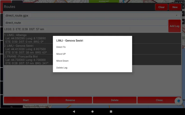
• create and manage your routes and legs
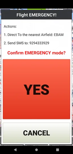
• MAYDAY button: send an automatic SMS with current location (only in devices that support this feature) and activation of a route to the nearest waypoint
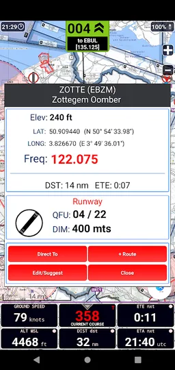
• Course with two navigation modes: a) visualization of the course you have to follow to reach the next waypoint or; b) visualization of how many degrees you have to turn to reach the next waypoint, while the arrow shows in which direction the point is in relation to the direction of your flight
• show real-time flight tracks
• save flight tracks to a GPX file for offline processing (visualize in specific apps or inside the GPS Air Navigator)
• visualize your flight stats and share them on Facebook, e-mail, Instagram and so on
• only one licence needed for all your Android devices
After install, you can try the app with the following limitations:
• you can save only two user waypoints;
• the app closes after 15 minutes of usage.
If you like GPS Air Navigator, you can buy a licence using the button Buy inside the app, to use it without limitations.
Enjoy GPS Air Navigator!
Follow us on https://www.facebook.com/gpsairnavigator!
Main features:
• real-time GPS moving map
• graphical visualization of country air space
• navigation with True or Magnetic North
• High Quality VFR Aeronautical Charts (from Flyermaps.com) for Portugal, Spain, Argentina, Chile, Colombia, Iceland, Uruguay and Venezuela
• free OpenStreetMap maps for all countries
• USA Sectional VFR Charts (generated from FAA VFR Raster Charts)
• WAC and REA Charts from Brazil (thanks to DECEA-Brazil)
• free OpenFlightMaps Charts from Netherlands, Poland, Croatia, Czech Republic, Belgium, Germany, Denmark, Sweden, Bulgaria, Hungary, Slovenia, Austria, Romania and Switzerland (thanks to the Openflightmaps Association)
• airspace information for Portugal with daily updates (integrated with FuaFlex service - www.cavok.pt)
• database with more than 56.000 system waypoints
• create and manage your own user waypoints
• create and manage your routes and legs
• MAYDAY button: send an automatic SMS with current location (only in devices that support this feature) and activation of a route to the nearest waypoint
• Course with two navigation modes: a) visualization of the course you have to follow to reach the next waypoint or; b) visualization of how many degrees you have to turn to reach the next waypoint, while the arrow shows in which direction the point is in relation to the direction of your flight
• show real-time flight tracks
• save flight tracks to a GPX file for offline processing (visualize in specific apps or inside the GPS Air Navigator)
• visualize your flight stats and share them on Facebook, e-mail, Instagram and so on
• only one licence needed for all your Android devices
After install, you can try the app with the following limitations:
• you can save only two user waypoints;
• the app closes after 15 minutes of usage.
If you like GPS Air Navigator, you can buy a licence using the button Buy inside the app, to use it without limitations.
Enjoy GPS Air Navigator!
Required features
- Faketouch android.hardware.faketouch
- Location android.hardware.location
Permissions (14)
GPS Air Navigator requests the following Android permissions:
- Access Coarse Location android.permission.ACCESS_COARSE_LOCATION
- Access Fine Location android.permission.ACCESS_FINE_LOCATION
- Access Network State android.permission.ACCESS_NETWORK_STATE
- Access Wifi State android.permission.ACCESS_WIFI_STATE
- Internet android.permission.INTERNET
- Read External Storage android.permission.READ_EXTERNAL_STORAGE
- Read Phone State android.permission.READ_PHONE_STATE
- Send Sms android.permission.SEND_SMS
- Wake Lock android.permission.WAKE_LOCK
- Write External Storage android.permission.WRITE_EXTERNAL_STORAGE
- Com Android Vending Billing com.android.vending.BILLING
- C2dm Permission Receive com.google.android.c2dm.permission.RECEIVE
- Com Nksoftware Gpsairnavigator Permission C2d Message com.nksoftware.gpsairnavigator.permission.C2D_MESSAGE
- Org Onepf Openiab Permission Billing org.onepf.openiab.permission.BILLING