
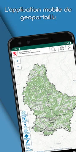
geoportail.lu
The official mapping app from Luxemburg’s national geoportal.
Administration du Cadastre et de la Topographie · com.c2c.LuxMob
UpdatedJan 3, 2026
PublishedMar 26, 2022
Packagecom.c2c.LuxMob
MD545b63eb24cd97133ff4f99357d49708b
SHA1 (signer)49:35:A1:B4:F8:82:53:74:70:DF:F3:64:4E:5E:48:7E:FC:F1:A8:C6
Signed byCN=Pierre GIRAUD, OU=geospatial, O=camptocamp, L=Chamb?ry, ST=France, C=FR
Malware scanTRUSTED
Websitehttp://www.act.public.lu
Contact[email protected]
What's new
- Download our vectortile style maps to use them in offline mode
- Small bug fixes
- Small bug fixes
Description
The official mapping app from Luxemburg’s national geoportal, developed by the Cadastre & Topography Administration (ACT).
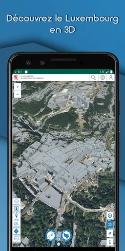
This app enables you to view topographic maps, aerial photos, and cadastral parcels as well as many other interesting datasets about Luxemburg via your mobile device.
✓SEARCH FOR PLACES: Search for places by names, toponymes, parcel numbers, coordinates etc…
✓Chose among more than 100 different data layers (as available on our website http://map.geoportal.lu)
✓Share your maps
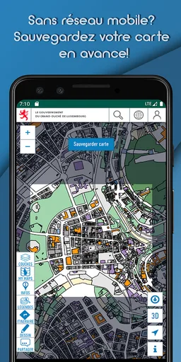
✓ Use maps in offline mode
!
Offline functionality:
Choose a specific zone to download to your device. The active map layers for this area will be available to use even when offline, for example when hiking in areas without network coverage. This functionality is also ideal to download our maps via Wi-Fi at home, without incurring excessive mobile data download charges or exceed your data quota.
!
✓ ACCESS QUALITY TRAILS
✓VISUALIZE HEIGHT PROFILES
✓ ENJOY A LOT OF OTHER FUNCTIONS
✓ create POIs on the map (thanks to the GPS, by coordinates , e.g Geocaching or inventories )
✓ Export GPX/KML files
WARNING: Continued use of GPS running in the background can dramatically decrease battery life. Continued use of maps in online mode may lead to unexpected costs due to high download traffic.
Check our PRIVACY POLICY at:
https://geoportail.lu/en/applications/mobile-apps/privacy-policy
This app enables you to view topographic maps, aerial photos, and cadastral parcels as well as many other interesting datasets about Luxemburg via your mobile device.
✓SEARCH FOR PLACES: Search for places by names, toponymes, parcel numbers, coordinates etc…
✓Chose among more than 100 different data layers (as available on our website http://map.geoportal.lu)
✓Share your maps
✓ Use maps in offline mode
!
Offline functionality:
Choose a specific zone to download to your device. The active map layers for this area will be available to use even when offline, for example when hiking in areas without network coverage. This functionality is also ideal to download our maps via Wi-Fi at home, without incurring excessive mobile data download charges or exceed your data quota.
!
✓ ACCESS QUALITY TRAILS
✓VISUALIZE HEIGHT PROFILES
✓ ENJOY A LOT OF OTHER FUNCTIONS
✓ create POIs on the map (thanks to the GPS, by coordinates , e.g Geocaching or inventories )
✓ Export GPX/KML files
WARNING: Continued use of GPS running in the background can dramatically decrease battery life. Continued use of maps in online mode may lead to unexpected costs due to high download traffic.
Check our PRIVACY POLICY at:
https://geoportail.lu/en/applications/mobile-apps/privacy-policy
Required features
- Faketouch android.hardware.faketouch
- Location android.hardware.location
Permissions (4)
geoportail.lu requests the following Android permissions:
- Access Coarse Location android.permission.ACCESS_COARSE_LOCATION
- Access Fine Location android.permission.ACCESS_FINE_LOCATION
- Internet android.permission.INTERNET
- Com C2c Luxmob Dynamic Receiver Not Exported Permission com.c2c.LuxMob.DYNAMIC_RECEIVER_NOT_EXPORTED_PERMISSION