
Geodesy Earth Tools
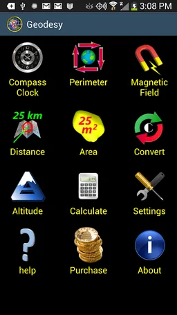
Measure perimeter, area, distance, altitude, magnetic field and coordinates.
DS Software · com.discipleskies.android.geodysey


UpdatedJan 17, 2026
PublishedJun 10, 2023
Packagecom.discipleskies.android.geodysey
MD5228ab86b4a70c2b9511f1b3ca4a0dd2c
SHA1 (signer)A0:D3:FD:89:A1:FC:57:F7:F5:04:26:7D:93:A0:29:81:0C:0E:3E:09
Signed byO=Disciple Skies Software, L=Las Cruces, ST=New Mexico, C=US
Malware scanTRUSTED
Websitehttp://www.discipleskies.com
Contact[email protected]
Privacy policyView
What's new
Bug fixes and other improvements.
Description
For Surveyors, Engineers, Navigators and Students of Geodesy...
Geodesy Earth Tools is the easiest way to make geographic calculations.
* Coordinate conversion tool with error checking: Convert Degrees, Deg/Min, Deg/Min/Sec, UTM, MGRS, Maidenhead.
* Draw any free-form closed shape on a map or point-plot a perimeter to get the enclosed area. Great if you just want to know the area of your neighbor's back yard or the area and perimeter of the continental U.S. Useful for construction planning, gardening, or any other task that requires area measurements.
* Plot 2 points on a map and get the altitudes, distance and altitude difference between them along with reverse geocoded locality information.
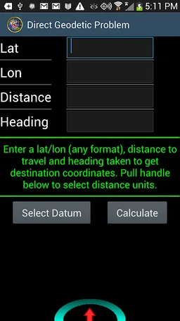
* Solutions for the direct and indirect geodetic problem.
* Lots of screens for making distance, area, heading and altitude calculations including, for the technically minded, a geodetic problem calculator for inverse and direct geodetic problems. Choose your geoid (DATUM).
* Distance from your position to any position on the globe.
* Magnetic field tools including A COMPASS with a magnetic declination indicator.
* Time measurements.
* Excellent documentation with easy to follow help.
Geodesy Earth Tools is the easiest way to make geographic calculations.
* Coordinate conversion tool with error checking: Convert Degrees, Deg/Min, Deg/Min/Sec, UTM, MGRS, Maidenhead.
* Draw any free-form closed shape on a map or point-plot a perimeter to get the enclosed area. Great if you just want to know the area of your neighbor's back yard or the area and perimeter of the continental U.S. Useful for construction planning, gardening, or any other task that requires area measurements.
* Plot 2 points on a map and get the altitudes, distance and altitude difference between them along with reverse geocoded locality information.
* Solutions for the direct and indirect geodetic problem.
* Lots of screens for making distance, area, heading and altitude calculations including, for the technically minded, a geodetic problem calculator for inverse and direct geodetic problems. Choose your geoid (DATUM).
* Distance from your position to any position on the globe.
* Magnetic field tools including A COMPASS with a magnetic declination indicator.
* Time measurements.
* Excellent documentation with easy to follow help.
Required features
- Faketouch android.hardware.faketouch
- Location android.hardware.location
- Location Gps android.hardware.location.gps
- Screen Portrait android.hardware.screen.portrait
Permissions (15)
Geodesy Earth Tools requests the following Android permissions:
- Access Adservices Ad Id android.permission.ACCESS_ADSERVICES_AD_ID
- Access Adservices Attribution android.permission.ACCESS_ADSERVICES_ATTRIBUTION
- Access Adservices Topics android.permission.ACCESS_ADSERVICES_TOPICS
- Access Coarse Location android.permission.ACCESS_COARSE_LOCATION
- Access Fine Location android.permission.ACCESS_FINE_LOCATION
- Access Network State android.permission.ACCESS_NETWORK_STATE
- Foreground Service android.permission.FOREGROUND_SERVICE
- Internet android.permission.INTERNET
- Vibrate android.permission.VIBRATE
- Wake Lock android.permission.WAKE_LOCK
- Com Android Vending Billing com.android.vending.BILLING
- Com Discipleskies Android Geodysey Dynamic Receiver Not Exported Permission com.discipleskies.android.geodysey.DYNAMIC_RECEIVER_NOT_EXPORTED_PERMISSION
- Com Discipleskies Android Geodysey Permission Maps Receive com.discipleskies.android.geodysey.permission.MAPS_RECEIVE
- Finsky Permission Bind Get Install Referrer Service com.google.android.finsky.permission.BIND_GET_INSTALL_REFERRER_SERVICE
- Gms Permission Ad Id com.google.android.gms.permission.AD_ID