
Flood Assist
Flood Assist provides you with Real Time Flood Alerts & Flood Risk Maps
Flood Assist · uk.co.floodassist


UpdatedJun 17, 2021
PublishedJun 17, 2021
Packageuk.co.floodassist
MD5493d6e23bb85ac3aa091344f1612d804
SHA1 (signer)F9:90:A6:68:BB:A8:C1:F4:C9:DE:36:24:F1:5C:3E:45:71:C0:A5:21
Signed byCN="Robin Clark, OU=Flood Assist, O=Flood Assist, L=Woodnewton, S=Northants, C=UK"
Architecturesx86, x86-64, armeabi-v7a, arm64-v8a
Malware scanUNKNOWN
Websitehttps://floodassist.co.uk
Contact[email protected]
Privacy policyView
What's new
Fixed bug with external logins
Description
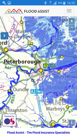
Flood Assist provides you with 2 vital pieces of information to allow you to better understand your risk of flooding for any location in England or Wales.
1. Real Time Flood Alerts – so you can understand your current risk of flooding
2. Flood Risk Maps – so you can understand your risk of flooding from rivers and the sea
We use trusted data obtained directly from the Environment Agency and National Resources Wales which is updated every 15 minutes. Using high resolution Ordnance Survey maps you are able to zoom in and locate your property.
We offer an email based Flood Alert service where we will send you an automated email when a Flood Alert, Flood Warning or Severe Flood Warning happens in one or more locations you have selected.
Our flood risk maps allow you to understand how likely your property is to flood by showing you if your property is located in a High, Medium, Low, or Very Low risk area.
Required features
- Faketouch android.hardware.faketouch
- Location android.hardware.location
Permissions (5)
Flood Assist requests the following Android permissions:
- Access Coarse Location android.permission.ACCESS_COARSE_LOCATION
- Access Fine Location android.permission.ACCESS_FINE_LOCATION
- Access Network State android.permission.ACCESS_NETWORK_STATE
- Internet android.permission.INTERNET
- Write External Storage android.permission.WRITE_EXTERNAL_STORAGE
