eGEO Compass ProDEMO IntGeoMod
Digiatal compass for geologists and engineers, for use in field surveys.
Marco Foi · eu.marcofoi.android.egeocompasspro


UpdatedAug 11, 2017
PublishedAug 11, 2017
Packageeu.marcofoi.android.egeocompasspro
MD5e71aabaf919f3a4d14b189bc66f98838
SHA1 (signer)65:55:A6:46:59:46:62:47:32:45:1F:03:E0:2C:B7:DA:AB:75:2A:EB
Signed byCN=Marco Foi, L=Milano, ST=Italy, C=IT
Malware scanTRUSTED
Contact[email protected]
Privacy policyView
What's new
V.1.1.28 - March, 14th 2016
Fixed bug in calling Browser during registration on Samsung devices
V.1.1.27 - April, 26th 2014
FRENCH translation
V.1.1.26 - April, 19th 2014
Just bug fixes and code optimization.
V.1.1.25 - March, 25th 2014
Added SHP (ESRI® Shapefile) export.
V.1.1.22
Added switchable labels to pole-marks in Wulff Stereoplot
V.1.1.21
Fixes for high-resolution devices exceeding 240ppi.
V.1.1.20
DEMO mode can be activated for data exporting.
Description
Geological Compass for Android
by IntGeoMod 2013
Digital compass for geology.
NEW FEATURES
- FRENCH Translation
- Export to SHP (ESRI® Shapefile) [requires registration].
--------
THIS APP REQUIRES REGISTRATION FOR EXPORTING DATA.
REGISTRATION CODES WILL BE ISSUED JUST TO SELECTED PARTNERS.
Individual professional users should try this app for evaluation then purchase paid version.
---------
Designed for the use in field surveys by geologists and engineers.
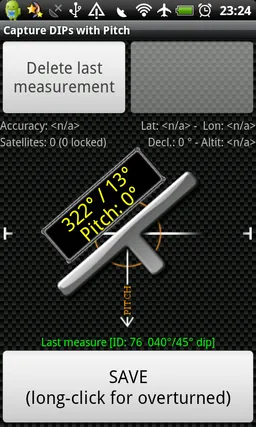
Allows the measure of both Dips (Dip-Azimuth and Dip-Angle) and Lineations of any surface/linear element without having to level the compass. Just lie down the phone on the plane or align its long side with the elongated element and click "Save".
Features:
- NEW: Export to SHP (ESRI® Shapefile) [requires registration].
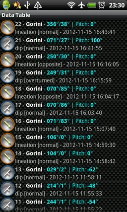
- Internal DB storage - unlimited (hosting more than 2000 measurements is discouraged)
- GPS support for geo-tagging
- Support for overturned (younging) measures by long-press on "Save" button
- Projects tags to allow data filtering both in in-app features and in exported data
- Map preview with tap-on-measure detail retrieving
- CVS and KMZ export [requires registration]
- CSV import
- Declination correction (manual or automatic from GPS position)
- Measure averaging
by IntGeoMod 2013
Digital compass for geology.
NEW FEATURES
- FRENCH Translation
- Export to SHP (ESRI® Shapefile) [requires registration].
--------
THIS APP REQUIRES REGISTRATION FOR EXPORTING DATA.
REGISTRATION CODES WILL BE ISSUED JUST TO SELECTED PARTNERS.
Individual professional users should try this app for evaluation then purchase paid version.
---------
Designed for the use in field surveys by geologists and engineers.
Allows the measure of both Dips (Dip-Azimuth and Dip-Angle) and Lineations of any surface/linear element without having to level the compass. Just lie down the phone on the plane or align its long side with the elongated element and click "Save".
Features:
- NEW: Export to SHP (ESRI® Shapefile) [requires registration].
- Internal DB storage - unlimited (hosting more than 2000 measurements is discouraged)
- GPS support for geo-tagging
- Support for overturned (younging) measures by long-press on "Save" button
- Projects tags to allow data filtering both in in-app features and in exported data
- Map preview with tap-on-measure detail retrieving
- CVS and KMZ export [requires registration]
- CSV import
- Declination correction (manual or automatic from GPS position)
- Measure averaging
Required features
- Location android.hardware.location
- Location Gps android.hardware.location.gps
- Location Network android.hardware.location.network
- Screen Portrait android.hardware.screen.portrait
- Touchscreen android.hardware.touchscreen
Permissions (8)
eGEO Compass ProDEMO IntGeoMod requests the following Android permissions:
- Access Coarse Location android.permission.ACCESS_COARSE_LOCATION
- Access Fine Location android.permission.ACCESS_FINE_LOCATION
- Internet android.permission.INTERNET
- Read Phone State android.permission.READ_PHONE_STATE
- Vibrate android.permission.VIBRATE
- Write External Storage android.permission.WRITE_EXTERNAL_STORAGE
- Write Owner Data android.permission.WRITE_OWNER_DATA
- Com Android Vending Billing com.android.vending.BILLING