
CityBus Mariupol
Smart app for online tracking public transport of Mariupol
d.u.a.l · ua.in.citybus.mariupol


UpdatedDec 8, 2025
PublishedMar 27, 2021
Packageua.in.citybus.mariupol
MD5787f212266d6b81c3eeb646fcd1b78ea
SHA1 (signer)93:5B:CE:9E:2F:B0:CE:2C:AD:2C:13:DC:FD:28:6C:70:25:B1:77:48
Signed byCN=Alexandr Dudyk, OU=IT, O=CityBus, L=Lutsk, ST=Volyn, C=UA
Architecturesx86, x86-64, armeabi-v7a, arm64-v8a
Malware scanTRUSTED
Contact[email protected]
Privacy policyView
What's new
Technical release so that the app remains in the Market as one of the monuments to what Mariupol has lost due to the actions of inhumans
Description
Smart app for tracking public transport of Mariupol.
* Main app function - transport tracking - depends on the functioning of an external source of GPS data. Cooperation of the source and app is not guaranteed. Also, given the significant intervals of data updates sometimes, there may be some differences between the real transport position and the one that shown in the application.
- Only actual information. CityBus filters data not to show you things, which aren't there.
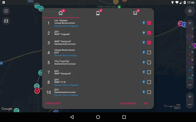
- Favourites. CityBus gives you possibility to save your favorite routes lists and apply them in just a couple of taps.
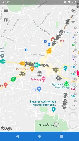
- Smart view. On map zoom in you will see all vehicles, equipped with GPS-trackers, not only of selected routes.
- Routes search. You only need to choose two points on a map, search results could be filtered and applied to display suitable vehicles.
- Real-time transition. Received info about coordinates, speed and heading is enough to predict with high probability real-time vehicle location. Displaying movement on a map is animated, almost no jumps.
- Traffic optimization. All useful info is already inside this app.
- Speed and heading visualization. Only one glance at map allows you to determine heading and speed of vehicles you need. Depending on speed changes size of colored area of ring around marker, and its center points in a direction the bus is heading.
- Color routes identification. Distinguishing routes is quite easy, 'cause every selected route is determined not only by its number, but although by color of its marker.
No state or government funds were used in the development of the application, the application is not owned by and is in no way affiliated with the government or any other government organizations and local governments. The application uses open data based on the Law of Ukraine "On Access to Public Information"
* Main app function - transport tracking - depends on the functioning of an external source of GPS data. Cooperation of the source and app is not guaranteed. Also, given the significant intervals of data updates sometimes, there may be some differences between the real transport position and the one that shown in the application.
- Only actual information. CityBus filters data not to show you things, which aren't there.
- Favourites. CityBus gives you possibility to save your favorite routes lists and apply them in just a couple of taps.
- Smart view. On map zoom in you will see all vehicles, equipped with GPS-trackers, not only of selected routes.
- Routes search. You only need to choose two points on a map, search results could be filtered and applied to display suitable vehicles.
- Real-time transition. Received info about coordinates, speed and heading is enough to predict with high probability real-time vehicle location. Displaying movement on a map is animated, almost no jumps.
- Traffic optimization. All useful info is already inside this app.
- Speed and heading visualization. Only one glance at map allows you to determine heading and speed of vehicles you need. Depending on speed changes size of colored area of ring around marker, and its center points in a direction the bus is heading.
- Color routes identification. Distinguishing routes is quite easy, 'cause every selected route is determined not only by its number, but although by color of its marker.
No state or government funds were used in the development of the application, the application is not owned by and is in no way affiliated with the government or any other government organizations and local governments. The application uses open data based on the Law of Ukraine "On Access to Public Information"
Required features
- Faketouch android.hardware.faketouch
- Location android.hardware.location
- Wifi android.hardware.wifi
Permissions (16)
CityBus Mariupol requests the following Android permissions:
- Access Adservices Ad Id android.permission.ACCESS_ADSERVICES_AD_ID
- Access Adservices Attribution android.permission.ACCESS_ADSERVICES_ATTRIBUTION
- Access Adservices Topics android.permission.ACCESS_ADSERVICES_TOPICS
- Access Coarse Location android.permission.ACCESS_COARSE_LOCATION
- Access Fine Location android.permission.ACCESS_FINE_LOCATION
- Access Network State android.permission.ACCESS_NETWORK_STATE
- Access Wifi State android.permission.ACCESS_WIFI_STATE
- Foreground Service android.permission.FOREGROUND_SERVICE
- Internet android.permission.INTERNET
- Post Notifications android.permission.POST_NOTIFICATIONS
- Wake Lock android.permission.WAKE_LOCK
- Com Android Vending Billing com.android.vending.BILLING
- C2dm Permission Receive com.google.android.c2dm.permission.RECEIVE
- Finsky Permission Bind Get Install Referrer Service com.google.android.finsky.permission.BIND_GET_INSTALL_REFERRER_SERVICE
- Gms Permission Ad Id com.google.android.gms.permission.AD_ID
- Ua In Citybus Mariupol Dynamic Receiver Not Exported Permission ua.in.citybus.mariupol.DYNAMIC_RECEIVER_NOT_EXPORTED_PERMISSION