
Cartes IGN
Discover France differently and observe the evolution of the territory
IGN - Géoportail · fr.ign.geoportail


UpdatedMar 13, 2026
PublishedJan 19, 2023
Packagefr.ign.geoportail
MD51df0ce1ef818180c2af7dcc79a4ca366
SHA1 (signer)EA:53:BC:61:CB:FD:69:D7:9D:55:C4:1B:54:38:99:49:E7:18:2E:6D
Signed byCN=IGN - G?oportail, OU=IGN, O=IGN, L=Saint-Mand?, ST=France, C=fr
Malware scanTRUSTED
Websitehttp://m.geoportail.fr
Contact[email protected]
Privacy policyView
What's new
Correction d'un bug lors de la modification d'un itinéraire tracé en saisie guidée.
Description
IGN Maps is the 100% free cartographic and navigation application designed by IGN, available on mobile and tablet. Find the precision of IGN base maps (IGN plan and topographic maps) combined with the wealth of thematic geographic data offered by the IGN and its partners (administrative, land, agriculture, forestry, tourism, protected areas, transport, etc.) to explore and understand the French territory.
Good plan ! Click on the interactive map to obtain additional information on French territory such as the characteristics of a building or the type of cultivation of a field.
Fly over France and observe the evolution of French landscapes in times of climate change by comparing, like a geographer, IGN maps or aerial photographs from different eras. Seen from the sky, the mark of man on the territory is surprising!
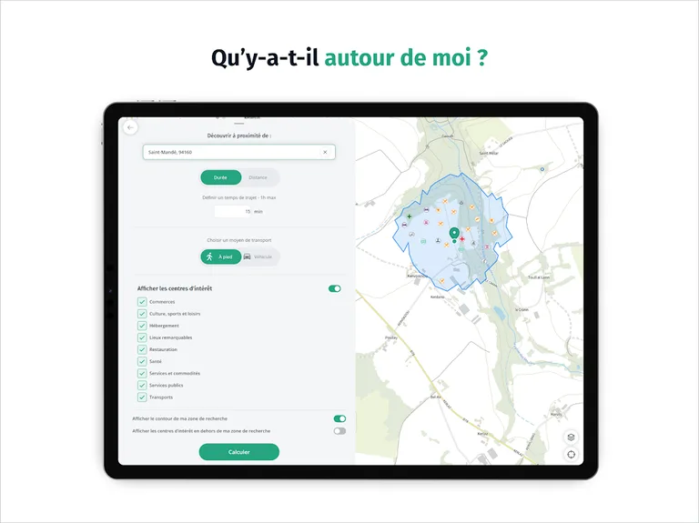
Discover points of interest around you thanks to IGN Maps, a mapping application for everyone, easy to use, which also offers all the practical tools to get around without being tracked: calculate a route, trace a route, create and save a landmark, display your position and share it with loved ones…
Set off to discover the French territory with IGN Maps!
Good plan ! Click on the interactive map to obtain additional information on French territory such as the characteristics of a building or the type of cultivation of a field.
Fly over France and observe the evolution of French landscapes in times of climate change by comparing, like a geographer, IGN maps or aerial photographs from different eras. Seen from the sky, the mark of man on the territory is surprising!
Discover points of interest around you thanks to IGN Maps, a mapping application for everyone, easy to use, which also offers all the practical tools to get around without being tracked: calculate a route, trace a route, create and save a landmark, display your position and share it with loved ones…
Set off to discover the French territory with IGN Maps!
Required features
- Faketouch android.hardware.faketouch
- Location android.hardware.location
Permissions (12)
Cartes IGN requests the following Android permissions:
- Access Coarse Location android.permission.ACCESS_COARSE_LOCATION
- Access Fine Location android.permission.ACCESS_FINE_LOCATION
- Access Network State android.permission.ACCESS_NETWORK_STATE
- Foreground Service android.permission.FOREGROUND_SERVICE
- Foreground Service Location android.permission.FOREGROUND_SERVICE_LOCATION
- Internet android.permission.INTERNET
- Post Notifications android.permission.POST_NOTIFICATIONS
- Read External Storage android.permission.READ_EXTERNAL_STORAGE
- Receive Boot Completed android.permission.RECEIVE_BOOT_COMPLETED
- Wake Lock android.permission.WAKE_LOCK
- Write External Storage android.permission.WRITE_EXTERNAL_STORAGE
- Fr Ign Geoportail Dynamic Receiver Not Exported Permission fr.ign.geoportail.DYNAMIC_RECEIVER_NOT_EXPORTED_PERMISSION