


UpdatedAug 8, 2017
PublishedAug 8, 2017
Packageeu.climent.area.app
MD50df7fcd589372bcf758657d1cc58bf52
SHA1 (signer)F8:12:C8:C4:04:41:7F:6D:CC:DB:22:63:C6:F1:E7:F0:86:37:A4:86
Signed byCN=Antonio Luis Climent Albaladejo, OU=Antonio Luis Climent Albaladejo, O=Antonio Luis Climent Albaladejo, L=Murcia, ST=Murcia, C=SP
Malware scanTRUSTED
Websitehttp://www.climent.eu
Contact[email protected]
Privacy policyView
What's new
- You can see the plane in google maps using MAP option.
- You can email a link to show the map using EMAIL option.
- The AUTHOR option shows you additional information about the author and his applications.
- Update required before October 15th, 2016 (Google Play platform change)
- You can email a link to show the map using EMAIL option.
- The AUTHOR option shows you additional information about the author and his applications.
- Update required before October 15th, 2016 (Google Play platform change)
Description
AREA
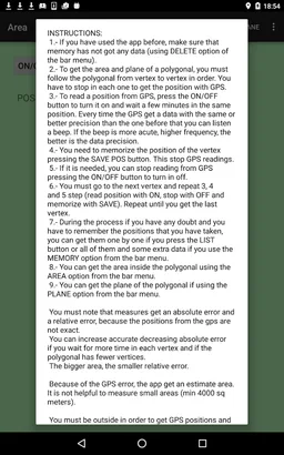
You can get the area and plane of a polygon following each of its vertices and getting its positions with the GPS of a mobile device.
The application displays an estimation of absolute error and the relative error in the measurements.
Because GPS positions have an error, the application is not useful for measuring small areas.
The app is helpful for the estimation of:
- The areas of land in agricultural or forest crops.
- Land areas when there are not sight lines between vertices (You cannot use telemeters).
- Water areas on the sea.
In other cases, you should seriously consider the relative error in the measurements.
Interface improved: saved positions with feedback to user when there is an internet connexion.
Required features
- Location android.hardware.location
- Location Gps android.hardware.location.gps
- Location Network android.hardware.location.network
- Screen Portrait android.hardware.screen.portrait
- Touchscreen android.hardware.touchscreen
Permissions (4)
Area requests the following Android permissions:
- Access Coarse Location android.permission.ACCESS_COARSE_LOCATION
- Access Fine Location android.permission.ACCESS_FINE_LOCATION
- Access Network State android.permission.ACCESS_NETWORK_STATE
- Internet android.permission.INTERNET