


UpdatedJul 25, 2025
PublishedApr 22, 2021
Packagecom.esri.earth.phone
MD51e0360e71b2e4ab4e8163bbc654b85f5
SHA1 (signer)DB:44:CB:80:C0:A8:0F:69:42:D0:86:54:DD:AE:7E:BE:90:01:56:E0
Signed byCN=David Cardella, OU=Esri, O=Esri, L=Redlands, ST=California, C=US
Architecturesarmeabi-v7a, arm64-v8a
Malware scanTRUSTED
Websitehttp://esri.com
Contact[email protected]
Privacy policyView
What's new
• You can now create custom map tiles from a supported online map or vector tile service and use them offline.
• High-accuracy GNSS devices sending NMEA messages can be used via Bluetooth. Switch between built-in and external devices.
• Support added for filtering, opening, and downloading mobile map packages from ArcGIS Online or Enterprise.
• App link enhanced with new parameters to share current view, including viewpoint, portal or service data, and basemap.
Description
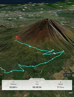
ArcGIS Earth transforms your mobile device into an interactive 3D globe for exploring geospatial data. Access authoritative organizational data, collect field data, perform measurements and exploratory analysis, and share insights with others. Whether you are online or offline, ArcGIS Earth puts the power of 3D visualization at your fingertips. Collaborate with key stakeholders to accelerate decision-making through a shared 3D perspective or digital twin of your data.
Key Features:
- View maps, GIS layers, and 3D content.
- Explore and visualize open 3D standards.
- Securely connect to your organizations ArcGIS Online or ArcGIS Enterprise portal.
- Search for places using world locator service or custom locator service.
- Draw points, lines, and areas on an interactive 3D globe.
- Add notes and attach photos to drawings.
- Share drawings as KMZs or publish to ArcGIS Portal.
- Create and share tours using placemarks or geotagged photos.
- Conduct interactive 2D and 3D measurements.
- Conduct 3D exploratory analysis like line of sight and viewshed.
- Record GPS tracks and save as a KMZ or publish to ArcGIS Portal.
- Integrate with other device apps to enable 3D visualization in field workflows.
- Position 3D data on a surface to see it in Augmented Reality.
Supported Online Data Services: ArcGIS Map Service, Image Service, Feature Service, Scene Service, Web Maps, Web Scenes, 3D Tiles Hosted Service, and KML / KMZ.
Supported Offline Data: Mobile Scene Package (.mspk), KML and KMZ files (.kml and .kmz), Tile Packages (.tpk and .tpkx), Vector Tile Packages (.vtpk), Scene Layer Packages (.spk and .slpk), GeoPackage (.gpkg), 3D Tiles (.3tz), Raster Data (.img, .dt, .tif, .jp2, .ntf, .sid, .dt0…)
Note: An account is not required to browse public data on ArcGIS Online and ArcGIS Living Atlas of the World, the world's foremost collection of geospatial information.
Note: This app requires you to have a licensed ArcGIS user type to access organizational content and services.
Required features
- Bluetooth android.hardware.bluetooth
- Faketouch android.hardware.faketouch
- Location android.hardware.location
- Location Gps android.hardware.location.gps
- Location Network android.hardware.location.network
- Screen Portrait android.hardware.screen.portrait
Permissions (20)
ArcGIS Earth requests the following Android permissions:
- Access Coarse Location android.permission.ACCESS_COARSE_LOCATION
- Access Fine Location android.permission.ACCESS_FINE_LOCATION
- Access Media Location android.permission.ACCESS_MEDIA_LOCATION
- Access Network State android.permission.ACCESS_NETWORK_STATE
- Bluetooth android.permission.BLUETOOTH
- Bluetooth Admin android.permission.BLUETOOTH_ADMIN
- Bluetooth Connect android.permission.BLUETOOTH_CONNECT
- Bluetooth Scan android.permission.BLUETOOTH_SCAN
- Camera android.permission.CAMERA
- Foreground Service android.permission.FOREGROUND_SERVICE
- Foreground Service Data Sync android.permission.FOREGROUND_SERVICE_DATA_SYNC
- Foreground Service Location android.permission.FOREGROUND_SERVICE_LOCATION
- Foreground Service Media Projection android.permission.FOREGROUND_SERVICE_MEDIA_PROJECTION
- Hide Overlay Windows android.permission.HIDE_OVERLAY_WINDOWS
- Internet android.permission.INTERNET
- Read External Storage android.permission.READ_EXTERNAL_STORAGE
- Read Media Images android.permission.READ_MEDIA_IMAGES
- Vibrate android.permission.VIBRATE
- Com Esri Earth Phone Dynamic Receiver Not Exported Permission com.esri.earth.phone.DYNAMIC_RECEIVER_NOT_EXPORTED_PERMISSION
- Read Media Visual User Selected READ_MEDIA_VISUAL_USER_SELECTED