
Airports Maps
View VAC Atlas Viewer Airports / Airfields on a Google Maps.
Stéphane Sandon · org.ssandon.map


UpdatedJun 15, 2021
PublishedJun 15, 2021
Packageorg.ssandon.map
MD5f5f90a405de62ffd6c1d64b2ed47cf77
SHA1 (signer)D5:6D:71:7F:8C:08:FA:E7:EB:16:C6:4A:80:9D:1C:99:71:2F:2D:E1
Signed byCN=SANDON St?phane, OU=Unknown, O=Unknown, L=Unknown, ST=Unknown, C=FR
Malware scanTRUSTED
Contact[email protected]
What's new
- Upgrade to AndroidX.
- Upgrade latest Android version.
- Upgrade latest Android version.
Description
Dear Friends Pilots,
Airports Maps is an application designed to simplify your flights.
This application requires VAC Atlas Viewer application on your device otherwise you won't have any data on the map.
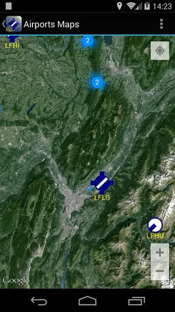
Airports Maps allows to view VAC Atlas Viewer's data on Google Maps. You can see on France map the position of the different airfields (open to public, restricted, mountain, helicopter).
Here is an overview of the differents features :
- View on Google Maps, airfields from VAC Atlas Viewer.
- Visualization of data with VAC Atlas Viewer.
- Display filters.
- Interface in French and English.
- Free application, ad free !
Good flights.
Stéphane (Pilot @ LFLG).
Airports Maps is an application designed to simplify your flights.
This application requires VAC Atlas Viewer application on your device otherwise you won't have any data on the map.
Airports Maps allows to view VAC Atlas Viewer's data on Google Maps. You can see on France map the position of the different airfields (open to public, restricted, mountain, helicopter).
Here is an overview of the differents features :
- View on Google Maps, airfields from VAC Atlas Viewer.
- Visualization of data with VAC Atlas Viewer.
- Display filters.
- Interface in French and English.
- Free application, ad free !
Good flights.
Stéphane (Pilot @ LFLG).
Required features
- Faketouch android.hardware.faketouch
- Location android.hardware.location
Permissions (7)
Airports Maps requests the following Android permissions:
- Access Coarse Location android.permission.ACCESS_COARSE_LOCATION
- Access Fine Location android.permission.ACCESS_FINE_LOCATION
- Access Network State android.permission.ACCESS_NETWORK_STATE
- Internet android.permission.INTERNET
- Write External Storage android.permission.WRITE_EXTERNAL_STORAGE
- Providers Gsf Permission Read Gservices com.google.android.providers.gsf.permission.READ_GSERVICES
- Org Ssandon Runner Permission Maps Receive org.ssandon.runner.permission.MAPS_RECEIVE