


UpdatedNov 30, 2021
PublishedNov 30, 2021
Packagecom.plots.ariwasch.adopt_a_plot
MD52772cd98bac9143b6d4fdacb9d1203c4
SHA1 (signer)D2:91:D7:D2:8A:7F:01:C9:A7:D9:54:9B:DC:E9:BA:D0:6B:35:C9:25
Signed byCN=Ari Wasch, O=Adopt-a-Plot, L=Bay Ridge, ST=Maryland
Architecturesx86, x86-64, armeabi-v7a, arm64-v8a
Malware scanTRUSTED
Websitehttp://www.bay-ridge.org
Contact[email protected]
Privacy policyView
What's new
Now includes BRCA Commons Area and follows the Adopt-a-Plot color scheme for plot boundaries.
Description
The Adopt-a-Plot app is a geolocation-based app that displays the user's real-time position in relation to pre-loaded, or user-defined, map-based polygons, and it contains several user-friendly features. The app was originally designed to help forest maintenance citizen volunteers (of the Bay Ridge Civic Association, in Maryland), and for that purpose, it contains 105 pre-loaded geofenced “plots.” However, any user, worldwide, can easily enter a self-defined polygon and use the app for similar real-time relative geo-position visualization purpose.
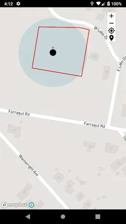
The Adopt-a-Plot app uses the phone’s GPS to continually triangulate and display the user’s geo-position. At the same time, the boundaries of the selected polygon are accurately displayed as a map overlay. The accuracy of the user’s location, in relation to plot boundaries, is limited only to the inherent accuracy of the phone’s GPS (typically about 15-30 feet). If needed, accuracy can be improved by pairing with an external GPS.
Users can simply scroll through a list of pre-loaded plots or create their own plot by inputting exact latitude and longitude coordinates. The app draws a red box around the desired area and displays the location of the user as a pulsing blue dot.
Included Features:
· Real-time positioning
· Drop down menu of currently programmed plots
· A coordinate input function
· Icons to zoom in and out of the map
· Accurate red border around the desired plot as map overlay
· Icons to switch the view between the user and the selected plot, and
· An instructions menu, specific to Bay Ridge, Maryland, that describes how to cut the invasive species in forests along with safety precautions of going into the forest.
This app can drain phone batteries, so it is suggested to bring a portable charger or turn off the phone when not in use.
This app was developed in 2019, as a “Community Challenge Project” for the benefit of the Bay Ridge Civic Association, by a group of South River High School junior year STEM students: Ari Wasch, Samara Hatley, and Nick Merton. In particular, Ari wrote the code using Xcode for the Apple app and Android Studio for the Android app.
Required features
- Faketouch android.hardware.faketouch
- Location android.hardware.location
- Screen Portrait android.hardware.screen.portrait
Permissions (4)
Adopt-a-Plot requests the following Android permissions:
- Access Fine Location android.permission.ACCESS_FINE_LOCATION
- Access Network State android.permission.ACCESS_NETWORK_STATE
- Access Wifi State android.permission.ACCESS_WIFI_STATE
- Internet android.permission.INTERNET